Gelemso geodata
Gelemso (Oromiya) is a populated place; located in Ethiopia in Africa/Addis_Ababa (GMT+3) time zone. With population of 16,065 people, there are 77 cities with bigger population in this country. Compared to other cities in Ethiopia, 53.3% of cities are located further ↑North; 88.8% of cities are located further ←West and 59.8% of cities have higher elevation than Gelemso. Note1


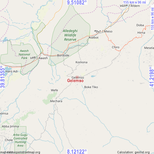
Gelemso GPS coordinates[2]
8° 49' 0.012" North, 40° 31' 0.012" East
| Map corner | latitude | longitude |
|---|---|---|
| Upper-left | 9.51082°, | 39.81355° |
| Center: | 8.81667°, | 40.51667° |
| Lower-right: | 8.12122°, | 41.2198° |
| Map W x H: | 154.5×154.5 km | = 96×96mi |
| max Lat: | 14.277° ⇑53.3% North |
| Gelemso: | 8.81667° |
| min Lat: | ⇓46.7% South 4.05° |
| min Long | Gelemso | max Long |
| 34.53333° | 40.51667° | 42.8° |
| W 88.8%⇐ | ⇒11.2% E |
Elevation
Elevation of Gelemso is 1795 m = 5889 ft, and this is 100.6 m = 330 ft below average elevation for this country.
| Max E: |
2854 m = 9364 ft | 59.8% |
| Avg. | 1895.6 m = 6219 ft | |
| Gelemso | 1795 m = 5889 ft | |
Min E: |
367 m = 1204 ft | 40.2% |
See also: Ethiopia elevation on elevation.city.
Geographical zone
Gelemso is located in North Torrid zone (between Equator and Tropic of Cancer). Distance of Equator is 980.3 km =609.1 mi to South.| Distance of | km | miles | from Gelemso |
|---|---|---|---|
| North Pole | 9026.7 | 5608.9 | to North |
| Arctic Circle | 6420.9 | 3989.8 | to North |
| Tropic Cancer | 1625.6 | 1010.1 | to North |
| Equator | 980.3 | 609.1 | to South |


Nearby cities:
15 places around Gelemso: (largest is in red/bold)
• Abomsa
142.3 km =88.4 mi,  335°
335°
• Bedēsa
30.7 km =19.1 mi,  72°
72°
• Debre Birhan
144.5 km =89.8 mi,  311°
311°
• Debre Sīna
141.5 km =87.9 mi,  324°
324°
• Deder
115.6 km =71.8 mi,  61°
61°
• Gewanē
150.8 km =93.7 mi,  5°
5°
• Huruta
148.2 km =92.1 mi,  239°
239°
• Hīrna
78 km =48.5 mi, 55°
• Metahāra
66.6 km =41.4 mi,  278°
278°
• Mojo
155.5 km =96.6 mi,  260°
260°
• Nazrēt
140.6 km =87.4 mi, 257°
• Sirre
126.5 km =78.6 mi, 243°
• Wenjī
141.6 km =88 mi,  253°
253°
• Āsbe Teferī
48.7 km =30.3 mi,  52°
52°
• Āwash
42.7 km =26.5 mi,  295°
295°
Sources, notices
• [Note1] Compared only with cities in Ethiopia existing in our database
• [Src1] Map data: © OpenStreetMap contributors (CC-BY-SA)
• [Src2] Other city data from geonames.org with taken over terms of usage.
• [Src3] Geographical zone / Annual Mean Temperature by Robert A. Rohde @ Wikipedia
