Debre Sīna geodata
Debre Sīna (Amhara) is a populated place; located in Ethiopia in Africa/Addis_Ababa (GMT+3) time zone. With population of 9,409 people, there are 96 cities with bigger population in this country. Compared to other cities in Ethiopia, 69.2% of cities are located further ↓South; 82.2% of cities are located further ←West and 96.3% of cities have lower elevation than Debre Sīna. Note1


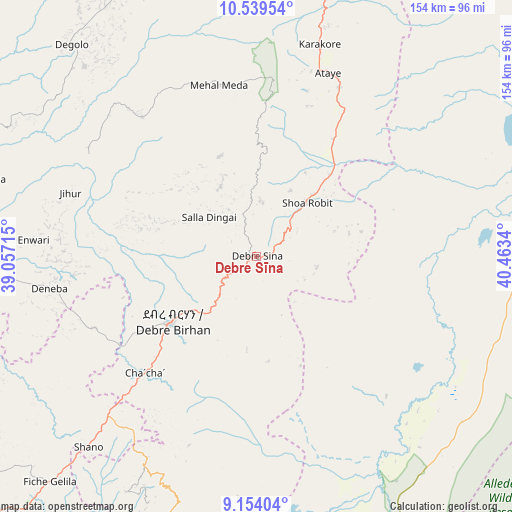
Debre Sīna GPS coordinates[2]
9° 50' 51.072" North, 39° 45' 36.972" East
| Map corner | latitude | longitude |
|---|---|---|
| Upper-left | 10.53954°, | 39.05715° |
| Center: | 9.84752°, | 39.76027° |
| Lower-right: | 9.15404°, | 40.4634° |
| Map W x H: | 154.1×154.1 km | = 95.8×95.8mi |
| max Lat: | 14.277° ⇑30.8% North |
| Debre Sīna: | 9.84752° |
| min Lat: | ⇓69.2% South 4.05° |
| min Long | Debre Sīna | max Long |
| 34.53333° | 39.76027° | 42.8° |
| W 82.2%⇐ | ⇒17.8% E |
Elevation
Elevation of Debre Sīna is 2703 m = 8868 ft, and this is 807.4 m = 2649 ft above average elevation for this country.
| Max E: |
2854 m = 9364 ft | 3.7% |
| Debre Sīna | 2703 m 8868 ft | |
| Avg. | 1895.6 m = 6219 ft | |
Min E: |
367 m = 1204 ft | 96.3% |
See also: Ethiopia elevation on elevation.city.
Geographical zone
Debre Sīna is located in North Torrid zone (between Equator and Tropic of Cancer). Distance of Equator is 1094.9 km =680.3 mi to South.| Distance of | km | miles | from Debre Sīna |
|---|---|---|---|
| North Pole | 8912.1 | 5537.7 | to North |
| Arctic Circle | 6306.2 | 3918.5 | to North |
| Tropic Cancer | 1511 | 938.9 | to North |
| Equator | 1094.9 | 680.3 | to South |


Nearby cities:
15 places around Debre Sīna: (largest is in red/bold)
• Abomsa
28.7 km =17.8 mi,  58°
58°
• Addis Ababa
143.9 km =89.4 mi,  230°
230°
• Bishoftu
149 km =92.6 mi,  215°
215°
• Debre Birhan
31.2 km =19.4 mi, 233°
• Desē
143.6 km =89.2 mi,  354°
354°
• Fichē
112.6 km =70 mi,  267°
267°
• Gelemso
141.5 km =87.9 mi,  144°
144°
• Gewanē
103.4 km =64.2 mi,  69°
69°
• Kemisē
97.4 km =60.5 mi,  7°
7°
• Kombolcha
137.2 km =85.3 mi,  359°
359°
• Metahāra
106.7 km =66.3 mi,  170°
170°
• Sendafa
111.9 km =69.5 mi, 226°
• Were Īlu
89.7 km =55.7 mi,  336°
336°
• Āsbe Teferī
148 km =92 mi,  124°
124°
• Āwash
105.9 km =65.8 mi,  155°
155°
Sources, notices
• [Note1] Compared only with cities in Ethiopia existing in our database
• [Src1] Map data: © OpenStreetMap contributors (CC-BY-SA)
• [Src2] Other city data from geonames.org with taken over terms of usage.
• [Src3] Geographical zone / Annual Mean Temperature by Robert A. Rohde @ Wikipedia
