Debre Birhan geodata
Debre Birhan (Amhara) is a populated place; located in Ethiopia in Africa/Addis_Ababa (GMT+3) time zone. With population of 57,787 people, there are 18 cities with bigger population in this country. Compared to other cities in Ethiopia, 65.4% of cities are located further ↓South; 77.6% of cities are located further ←West and 99.1% of cities have lower elevation than Debre Birhan. Note1


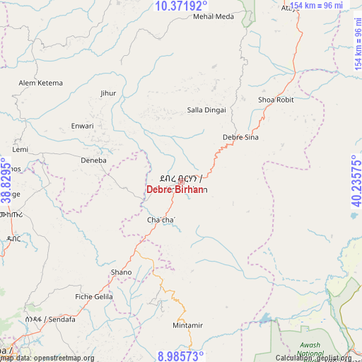
Debre Birhan GPS coordinates[2]
9° 40' 46.344" North, 39° 31' 57.432" East
| Map corner | latitude | longitude |
|---|---|---|
| Upper-left | 10.37192°, | 38.8295° |
| Center: | 9.67954°, | 39.53262° |
| Lower-right: | 8.98573°, | 40.23575° |
| Map W x H: | 154.1×154.1 km | = 95.8×95.8mi |
| max Lat: | 14.277° ⇑34.6% North |
| Debre Birhan: | 9.67954° |
| min Lat: | ⇓65.4% South 4.05° |
| min Long | Debre Birhan | max Long |
| 34.53333° | 39.53262° | 42.8° |
| W 77.6%⇐ | ⇒22.4% E |
Elevation
Elevation of Debre Birhan is 2830 m = 9285 ft, and this is 934.4 m = 3066 ft above average elevation for this country.
| Max E: |
2854 m = 9364 ft | 0.90000000000001% |
| Debre Birhan | 2830 m 9285 ft | |
| Avg. | 1895.6 m = 6219 ft | |
Min E: |
367 m = 1204 ft | 99.1% |
See also: Debre Birhan elevation on elevation.city.
Geographical zone
Debre Birhan is located in North Torrid zone (between Equator and Tropic of Cancer). Distance of Equator is 1076.3 km =668.8 mi to South.| Distance of | km | miles | from Debre Birhan |
|---|---|---|---|
| North Pole | 8930.8 | 5549.3 | to North |
| Arctic Circle | 6324.9 | 3930.1 | to North |
| Tropic Cancer | 1529.7 | 950.5 | to North |
| Equator | 1076.3 | 668.8 | to South |


Nearby cities:
15 places around Debre Birhan: (largest is in red/bold)
• Abomsa
59.8 km =37.2 mi,  55°
55°
• Addis Ababa
112.8 km =70.1 mi,  229°
229°
• Bishoftu
119.7 km =74.4 mi,  210°
210°
• Debre Sīna
31.2 km =19.4 mi,  53°
53°
• Fichē
88.6 km =55.1 mi,  278°
278°
• Gebre Guracha
124.8 km =77.5 mi, 276°
• Genet
132.2 km =82.1 mi,  238°
238°
• Kemisē
121.1 km =75.2 mi,  17°
17°
• Metahāra
96.4 km =59.9 mi,  154°
154°
• Mojo
129.6 km =80.5 mi,  200°
200°
• Nazrēt
128.9 km =80.1 mi,  193°
193°
• Sebeta
131.5 km =81.7 mi, 229°
• Sendafa
81 km =50.3 mi,  223°
223°
• Were Īlu
101.7 km =63.2 mi,  354°
354°
• Āwash
104.1 km =64.7 mi,  138°
138°
Sources, notices
• [Note1] Compared only with cities in Ethiopia existing in our database
• [Src1] Map data: © OpenStreetMap contributors (CC-BY-SA)
• [Src2] Other city data from geonames.org with taken over terms of usage.
• [Src3] Geographical zone / Annual Mean Temperature by Robert A. Rohde @ Wikipedia
