Kibre Mengist geodata
Kibre Mengist (Oromiya) is a populated place; located in Ethiopia in Africa/Addis_Ababa (GMT+3) time zone. With population of 27,854 people, there are 43 cities with bigger population in this country. Compared to other cities in Ethiopia, 90.7% of cities are located further ↑North; 64.5% of cities are located further ←West and 71% of cities have higher elevation than Kibre Mengist. Note1


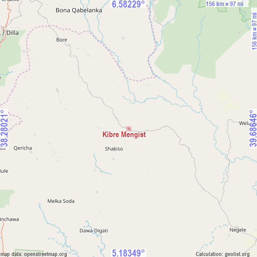
Kibre Mengist GPS coordinates[2]
5° 52' 59.988" North, 38° 58' 59.988" East
| Map corner | latitude | longitude |
|---|---|---|
| Upper-left | 6.58229°, | 38.28021° |
| Center: | 5.88333°, | 38.98333° |
| Lower-right: | 5.18349°, | 39.68646° |
| Map W x H: | 155.5×155.5 km | = 96.6×96.6mi |
| max Lat: | 14.277° ⇑90.7% North |
| Kibre Mengist: | 5.88333° |
| min Lat: | ⇓9.3% South 4.05° |
| min Long | Kibre Mengist | max Long |
| 34.53333° | 38.98333° | 42.8° |
| W 64.5%⇐ | ⇒35.5% E |
Elevation
Elevation of Kibre Mengist is 1690 m = 5545 ft, and this is 205.6 m = 675 ft below average elevation for this country.
| Max E: |
2854 m = 9364 ft | 71% |
| Avg. | 1895.6 m = 6219 ft | |
| Kibre Mengist | 1690 m = 5545 ft | |
Min E: |
367 m = 1204 ft | 29% |
See also: Ethiopia elevation on elevation.city.
Geographical zone
Kibre Mengist is located in North Torrid zone (between Equator and Tropic of Cancer). Distance of Equator is 654.2 km =406.5 mi to South.| Distance of | km | miles | from Kibre Mengist |
|---|---|---|---|
| North Pole | 9352.9 | 5811.6 | to North |
| Arctic Circle | 6747 | 4192.4 | to North |
| Tropic Cancer | 1951.8 | 1212.8 | to North |
| Equator | 654.2 | 406.5 | to South |


Nearby cities:
15 places around Kibre Mengist: (largest is in red/bold)
• Arba Minch
159.4 km =99 mi,  276°
276°
• Dodola
124.3 km =77.2 mi,  10°
10°
• Dīla
94.6 km =58.8 mi,  308°
308°
• Goba
167.6 km =104.1 mi,  41°
41°
• Hagere Maryam
87.2 km =54.2 mi,  251°
251°
• Hawassa
142.5 km =88.5 mi,  336°
336°
• Hāgere Selam
84.3 km =52.4 mi,  322°
322°
• Kofelē
133.4 km =82.9 mi,  350°
350°
• Leku
125.1 km =77.7 mi,  331°
331°
• Shakiso
15.5 km =9.6 mi,  211°
211°
• Shashemenē
152.4 km =94.7 mi, 343°
• Wendo
101.4 km =63 mi, 321°
• Yabēlo
149.3 km =92.8 mi,  221°
221°
• Yirga ‘Alem
114.9 km =71.4 mi, 326°
• Āsasa
137.4 km =85.4 mi, 10°
Sources, notices
• [Note1] Compared only with cities in Ethiopia existing in our database
• [Src1] Map data: © OpenStreetMap contributors (CC-BY-SA)
• [Src2] Other city data from geonames.org with taken over terms of usage.
• [Src3] Geographical zone / Annual Mean Temperature by Robert A. Rohde @ Wikipedia
