Goba geodata
Goba (Oromiya) is a populated place; located in Ethiopia in Africa/Addis_Ababa (GMT+3) time zone. With population of 34,369 people, there are 29 cities with bigger population in this country. Compared to other cities in Ethiopia, 79.4% of cities are located further ↑North; 85% of cities are located further ←West and 93.5% of cities have lower elevation than Goba. Note1


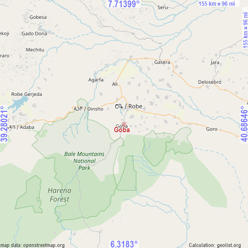
Goba GPS coordinates[2]
7° 1' 0.012" North, 39° 58' 59.988" East
| Map corner | latitude | longitude |
|---|---|---|
| Upper-left | 7.71399°, | 39.28021° |
| Center: | 7.01667°, | 39.98333° |
| Lower-right: | 6.3183°, | 40.68646° |
| Map W x H: | 155.2×155.2 km | = 96.4×96.4mi |
| max Lat: | 14.277° ⇑79.4% North |
| Goba: | 7.01667° |
| min Lat: | ⇓20.6% South 4.05° |
| min Long | Goba | max Long |
| 34.53333° | 39.98333° | 42.8° |
| W 85%⇐ | ⇒15% E |
Elevation
Elevation of Goba is 2682 m = 8799 ft, and this is 786.4 m = 2580 ft above average elevation for this country.
| Max E: |
2854 m = 9364 ft | 6.5% |
| Goba | 2682 m 8799 ft | |
| Avg. | 1895.6 m = 6219 ft | |
Min E: |
367 m = 1204 ft | 93.5% |
See also: Ethiopia elevation on elevation.city.
Geographical zone
Goba is located in North Torrid zone (between Equator and Tropic of Cancer). Distance of Equator is 780.2 km =484.8 mi to South.| Distance of | km | miles | from Goba |
|---|---|---|---|
| North Pole | 9226.9 | 5733.3 | to North |
| Arctic Circle | 6621 | 4114.1 | to North |
| Tropic Cancer | 1825.7 | 1134.4 | to North |
| Equator | 780.2 | 484.8 | to South |


Nearby cities:
15 places around Goba: (largest is in red/bold)
• Dodola
88.4 km =54.9 mi,  267°
267°
• Ginir
81.4 km =50.6 mi,  80°
80°
• Hawassa
166.4 km =103.4 mi, 271°
• Huruta
144.1 km =89.5 mi,  331°
331°
• Hāgere Selam
172.5 km =107.2 mi,  249°
249°
• Kibre Mengist
167.6 km =104.1 mi,  221°
221°
• Kofelē
132.5 km =82.3 mi, 272°
• Leku
170.6 km =106 mi,  264°
264°
• Shashemenē
154 km =95.7 mi,  277°
277°
• Sirre
154.7 km =96.1 mi,  339°
339°
• Wendo
179.1 km =111.3 mi, 255°
• Wenjī
177.1 km =110 mi, 334°
• Yirga ‘Alem
175.5 km =109.1 mi, 260°
• Ziway
172.9 km =107.4 mi,  306°
306°
• Āsasa
86.9 km =54 mi, 276°
Sources, notices
• [Note1] Compared only with cities in Ethiopia existing in our database
• [Src1] Map data: © OpenStreetMap contributors (CC-BY-SA)
• [Src2] Other city data from geonames.org with taken over terms of usage.
• [Src3] Geographical zone / Annual Mean Temperature by Robert A. Rohde @ Wikipedia
