Bichena geodata
Bichena (Amhara) is a populated place; located in Ethiopia in Africa/Addis_Ababa (GMT+3) time zone. With population of 16,411 people, there are 76 cities with bigger population in this country. Compared to other cities in Ethiopia, 74.8% of cities are located further ↓South; 57.9% of cities are located further →East and 88.8% of cities have lower elevation than Bichena. Note1


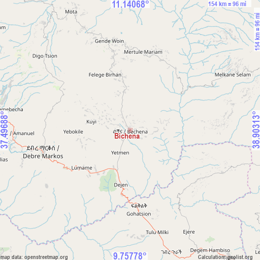
Bichena GPS coordinates[2]
10° 27' 0" North, 38° 12' 0" East
| Map corner | latitude | longitude |
|---|---|---|
| Upper-left | 11.14068°, | 37.49688° |
| Center: | 10.45°, | 38.2° |
| Lower-right: | 9.75778°, | 38.90313° |
| Map W x H: | 153.8×153.8 km | = 95.6×95.6mi |
| max Lat: | 14.277° ⇑25.2% North |
| Bichena: | 10.45° |
| min Lat: | ⇓74.8% South 4.05° |
| min Long | Bichena | max Long |
| 34.53333° | 38.2° | 42.8° |
| W 42.1%⇐ | ⇒57.9% E |
Elevation
Elevation of Bichena is 2544 m = 8346 ft, and this is 648.4 m = 2127 ft above average elevation for this country.
| Max E: |
2854 m = 9364 ft | 11.2% |
| Bichena | 2544 m 8346 ft | |
| Avg. | 1895.6 m = 6219 ft | |
Min E: |
367 m = 1204 ft | 88.8% |
See also: Ethiopia elevation on elevation.city.
Geographical zone
Bichena is located in North Torrid zone (between Equator and Tropic of Cancer). Distance of Equator is 1161.9 km =722 mi to South.| Distance of | km | miles | from Bichena |
|---|---|---|---|
| North Pole | 8845.1 | 5496.1 | to North |
| Arctic Circle | 6239.2 | 3876.9 | to North |
| Tropic Cancer | 1444 | 897.3 | to North |
| Equator | 1161.9 | 722 | to South |


Nearby cities:
15 places around Bichena: (largest is in red/bold)
• Addiet Canna
119.9 km =74.5 mi,  319°
319°
• Bahir Dar
154.8 km =96.2 mi,  325°
325°
• Burē
127 km =78.9 mi,  282°
282°
• Debre Mark’os
52.2 km =32.4 mi,  257°
257°
• Debre Tabor
156.9 km =97.5 mi,  352°
352°
• Debre Werk’
24.4 km =15.2 mi, 351°
• Dejen
32.3 km =20.1 mi,  193°
193°
• Fichē
92.9 km =57.7 mi,  141°
141°
• Finote Selam
105.7 km =65.7 mi,  285°
285°
• Gebre Guracha
75.5 km =46.9 mi,  163°
163°
• Genet
157.3 km =97.7 mi,  167°
167°
• Hāgere Hiywet
167.5 km =104.1 mi, 193°
• Shambu
155.4 km =96.6 mi,  230°
230°
• Were Īlu
136.2 km =84.6 mi,  83°
83°
• Ādīs ‘Alem
159 km =98.8 mi, 172°
Sources, notices
• [Note1] Compared only with cities in Ethiopia existing in our database
• [Src1] Map data: © OpenStreetMap contributors (CC-BY-SA)
• [Src2] Other city data from geonames.org with taken over terms of usage.
• [Src3] Geographical zone / Annual Mean Temperature by Robert A. Rohde @ Wikipedia
