Were Īlu geodata
Were Īlu (Amhara) is a populated place; located in Ethiopia in Africa/Addis_Ababa (GMT+3) time zone. With population of 7,636 people, there are 99 cities with bigger population in this country. Compared to other cities in Ethiopia, 75.7% of cities are located further ↓South; 72.9% of cities are located further ←West and 95.3% of cities have lower elevation than Were Īlu. Note1


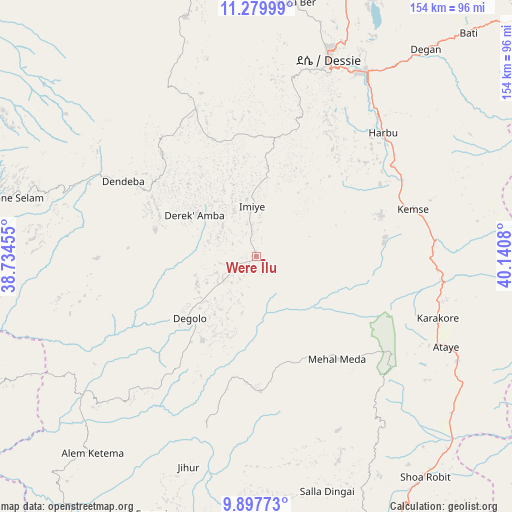
Were Īlu GPS coordinates[2]
10° 35' 22.704" North, 39° 26' 15.612" East
| Map corner | latitude | longitude |
|---|---|---|
| Upper-left | 11.27999°, | 38.73455° |
| Center: | 10.58964°, | 39.43767° |
| Lower-right: | 9.89773°, | 40.1408° |
| Map W x H: | 153.7×153.7 km | = 95.5×95.5mi |
| max Lat: | 14.277° ⇑24.3% North |
| Were Īlu: | 10.58964° |
| min Lat: | ⇓75.7% South 4.05° |
| min Long | Were Īlu | max Long |
| 34.53333° | 39.43767° | 42.8° |
| W 72.9%⇐ | ⇒27.1% E |
Elevation
Elevation of Were Īlu is 2699 m = 8855 ft, and this is 803.4 m = 2636 ft above average elevation for this country.
| Max E: |
2854 m = 9364 ft | 4.7% |
| Were Īlu | 2699 m 8855 ft | |
| Avg. | 1895.6 m = 6219 ft | |
Min E: |
367 m = 1204 ft | 95.3% |
See also: Ethiopia elevation on elevation.city.
Geographical zone
Were Īlu is located in North Torrid zone (between Equator and Tropic of Cancer). Distance of Equator is 1177.5 km =731.7 mi to South.| Distance of | km | miles | from Were Īlu |
|---|---|---|---|
| North Pole | 8829.6 | 5486.5 | to North |
| Arctic Circle | 6223.7 | 3867.2 | to North |
| Tropic Cancer | 1428.5 | 887.6 | to North |
| Equator | 1177.5 | 731.7 | to South |


Nearby cities:
15 places around Were Īlu: (largest is in red/bold)
• Abomsa
90 km =55.9 mi,  138°
138°
• Batī
92.1 km =57.2 mi,  43°
43°
• Bichena
136.2 km =84.6 mi,  263°
263°
• Debre Birhan
101.7 km =63.2 mi,  174°
174°
• Debre Sīna
89.7 km =55.7 mi,  156°
156°
• Debre Werk’
139.2 km =86.5 mi,  273°
273°
• Dejen
150.2 km =93.3 mi,  251°
251°
• Desē
64.1 km =39.8 mi,  19°
19°
• Fichē
116.8 km =72.6 mi,  221°
221°
• Gebre Guracha
143.5 km =89.2 mi,  232°
232°
• Gewanē
140.4 km =87.2 mi,  109°
109°
• Kemisē
49.3 km =30.6 mi,  73°
73°
• Kombolcha
64.1 km =39.8 mi,  31°
31°
• Lalībela
165.9 km =103.1 mi,  345°
345°
• Robīt
160.1 km =99.5 mi,  7°
7°
Sources, notices
• [Note1] Compared only with cities in Ethiopia existing in our database
• [Src1] Map data: © OpenStreetMap contributors (CC-BY-SA)
• [Src2] Other city data from geonames.org with taken over terms of usage.
• [Src3] Geographical zone / Annual Mean Temperature by Robert A. Rohde @ Wikipedia
