Debre Werk’ geodata
Debre Werk’ (Amhara) is a populated place; located in Ethiopia in Africa/Addis_Ababa (GMT+3) time zone. With population of 10,579 people, there are 91 cities with bigger population in this country. Compared to other cities in Ethiopia, 76.6% of cities are located further ↓South; 58.9% of cities are located further →East and 86.9% of cities have lower elevation than Debre Werk’. Note1


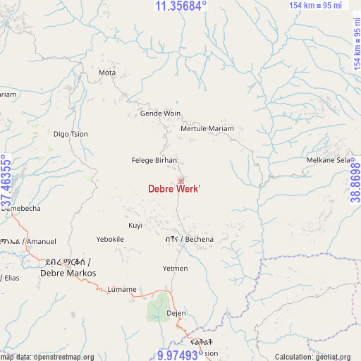
Debre Werk’ GPS coordinates[2]
10° 40' 0.012" North, 38° 10' 0.012" East
| Map corner | latitude | longitude |
|---|---|---|
| Upper-left | 11.35684°, | 37.46355° |
| Center: | 10.66667°, | 38.16667° |
| Lower-right: | 9.97493°, | 38.8698° |
| Map W x H: | 153.7×153.7 km | = 95.5×95.5mi |
| max Lat: | 14.277° ⇑23.4% North |
| Debre Werk’: | 10.66667° |
| min Lat: | ⇓76.6% South 4.05° |
| min Long | Debre Werk’ | max Long |
| 34.53333° | 38.16667° | 42.8° |
| W 41.1%⇐ | ⇒58.9% E |
Elevation
Elevation of Debre Werk’ is 2513 m = 8245 ft, and this is 617.4 m = 2026 ft above average elevation for this country.
| Max E: |
2854 m = 9364 ft | 13.1% |
| Debre Werk’ | 2513 m 8245 ft | |
| Avg. | 1895.6 m = 6219 ft | |
Min E: |
367 m = 1204 ft | 86.9% |
See also: Ethiopia elevation on elevation.city.
Geographical zone
Debre Werk’ is located in North Torrid zone (between Equator and Tropic of Cancer). Distance of Equator is 1186 km =736.9 mi to South.| Distance of | km | miles | from Debre Werk’ |
|---|---|---|---|
| North Pole | 8821 | 5481.1 | to North |
| Arctic Circle | 6215.2 | 3861.9 | to North |
| Tropic Cancer | 1419.9 | 882.3 | to North |
| Equator | 1186 | 736.9 | to South |


Nearby cities:
15 places around Debre Werk’: (largest is in red/bold)
• Addiet Canna
100.1 km =62.2 mi,  311°
311°
• Bahir Dar
133.4 km =82.9 mi,  320°
320°
• Bichena
24.4 km =15.2 mi,  171°
171°
• Burē
120.2 km =74.7 mi,  271°
271°
• Debre Mark’os
59 km =36.7 mi,  233°
233°
• Debre Tabor
132.6 km =82.4 mi,  352°
352°
• Dejen
55.7 km =34.6 mi,  183°
183°
• Desē
168.3 km =104.6 mi,  72°
72°
• Fichē
114.6 km =71.2 mi,  147°
147°
• Finote Selam
98.4 km =61.1 mi, 272°
• Gebre Guracha
99.7 km =62 mi, 165°
• Shambu
169.1 km =105.1 mi,  223°
223°
• Were Īlu
139.2 km =86.5 mi,  93°
93°
• Werota
148 km =92 mi,  339°
339°
• Ādīs Zemen
166.6 km =103.5 mi, 345°
Sources, notices
• [Note1] Compared only with cities in Ethiopia existing in our database
• [Src1] Map data: © OpenStreetMap contributors (CC-BY-SA)
• [Src2] Other city data from geonames.org with taken over terms of usage.
• [Src3] Geographical zone / Annual Mean Temperature by Robert A. Rohde @ Wikipedia
