Debre Tabor geodata
Debre Tabor (Amhara) is a populated place; located in Ethiopia in Africa/Addis_Ababa (GMT+3) time zone. With population of 32,659 people, there are 34 cities with bigger population in this country. Compared to other cities in Ethiopia, 87.9% of cities are located further ↓South; 62.6% of cities are located further →East and 94.4% of cities have lower elevation than Debre Tabor. Note1


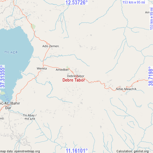
Debre Tabor GPS coordinates[2]
11° 51' 0" North, 38° 1' 0.012" East
| Map corner | latitude | longitude |
|---|---|---|
| Upper-left | 12.53726°, | 37.31355° |
| Center: | 11.85°, | 38.01667° |
| Lower-right: | 11.16101°, | 38.7198° |
| Map W x H: | 153×153 km | = 95.1×95.1mi |
| max Lat: | 14.277° ⇑12.1% North |
| Debre Tabor: | 11.85° |
| min Lat: | ⇓87.9% South 4.05° |
| min Long | Debre Tabor | max Long |
| 34.53333° | 38.01667° | 42.8° |
| W 37.4%⇐ | ⇒62.6% E |
Elevation
Elevation of Debre Tabor is 2692 m = 8832 ft, and this is 796.4 m = 2613 ft above average elevation for this country.
| Max E: |
2854 m = 9364 ft | 5.6% |
| Debre Tabor | 2692 m 8832 ft | |
| Avg. | 1895.6 m = 6219 ft | |
Min E: |
367 m = 1204 ft | 94.4% |
See also: Ethiopia elevation on elevation.city.
Geographical zone
Debre Tabor is located in North Torrid zone (between Equator and Tropic of Cancer). Distance of this Northern Tropic circle is 1288.3 km =800.5 mi to North.| Distance of | km | miles | from Debre Tabor |
|---|---|---|---|
| North Pole | 8689.5 | 5399.4 | to North |
| Arctic Circle | 6083.6 | 3780.2 | to North |
| Tropic Cancer | 1288.3 | 800.5 | to North |
| Equator | 1317.6 | 818.7 | to South |


Nearby cities:
15 places around Debre Tabor: (largest is in red/bold)
• Addiet Canna
87.1 km =54.1 mi,  221°
221°
• Bahir Dar
73.9 km =45.9 mi,  247°
247°
• Bichena
156.9 km =97.5 mi,  172°
172°
• Burē
164.6 km =102.3 mi, 219°
• Dabat
129 km =80.2 mi,  347°
347°
• Debark’
145.8 km =90.6 mi, 354°
• Debre Mark’os
169.6 km =105.4 mi,  190°
190°
• Debre Werk’
132.6 km =82.4 mi, 172°
• Finote Selam
151.8 km =94.3 mi,  212°
212°
• Gondar
102.6 km =63.8 mi,  324°
324°
• Korem
179.2 km =111.3 mi,  65°
65°
• Lalībela
114 km =70.8 mi,  79°
79°
• Robīt
176.8 km =109.9 mi, 83°
• Werota
35.2 km =21.9 mi,  282°
282°
• Ādīs Zemen
39 km =24.2 mi, 319°
Sources, notices
• [Note1] Compared only with cities in Ethiopia existing in our database
• [Src1] Map data: © OpenStreetMap contributors (CC-BY-SA)
• [Src2] Other city data from geonames.org with taken over terms of usage.
• [Src3] Geographical zone / Annual Mean Temperature by Robert A. Rohde @ Wikipedia
