Bahir Dar geodata
Bahir Dar (Amhara) is a seat of a first-order administrative division; located in Ethiopia in Africa/Addis_Ababa (GMT+3) time zone. With population of 168,899 people, there are 4 cities with bigger population in this country. Compared to other cities in Ethiopia, 85% of cities are located further ↓South; 78.5% of cities are located further →East and 58.9% of cities have higher elevation than Bahir Dar. Note1


Bahir Dar GPS coordinates[2]
11° 35' 37.104" North, 37° 23' 26.772" East
| Map corner | latitude | longitude |
|---|---|---|
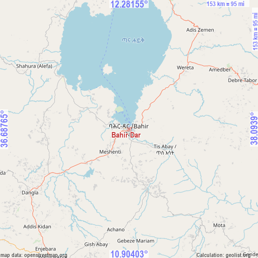
| Upper-left | 12.28155°, | 36.68765° |
| Center: | 11.59364°, | 37.39077° |
| Lower-right: | 10.90403°, | 38.0939° |
| Map W x H: | 153.2×153.2 km | = 95.2×95.2mi |
| max Lat: | 14.277° ⇑15% North |
| Bahir Dar: | 11.59364° |
| min Lat: | ⇓85% South 4.05° |
| min Long | Bahir Dar | max Long |
| 34.53333° | 37.39077° | 42.8° |
| W 21.5%⇐ | ⇒78.5% E |
Elevation
Elevation of Bahir Dar is 1799 m = 5902 ft, and this is 96.6 m = 317 ft below average elevation for this country.
| Max E: |
2854 m = 9364 ft | 58.9% |
| Avg. | 1895.6 m = 6219 ft | |
| Bahir Dar | 1799 m = 5902 ft | |
Min E: |
367 m = 1204 ft | 41.1% |
See also: Bahir Dar elevation on elevation.city.
Geographical zone
Bahir Dar is located in North Torrid zone (between Equator and Tropic of Cancer). Distance of Equator is 1289.1 km =801 mi to South.| Distance of | km | miles | from Bahir Dar |
|---|---|---|---|
| North Pole | 8718 | 5417.1 | to North |
| Arctic Circle | 6112.1 | 3797.9 | to North |
| Tropic Cancer | 1316.8 | 818.2 | to North |
| Equator | 1289.1 | 801 | to South |


Nearby cities:
15 places around Bahir Dar: (largest is in red/bold)
• Addiet Canna
37.7 km =23.4 mi,  164°
164°
• Bichena
154.8 km =96.2 mi,  145°
145°
• Burē
105.5 km =65.6 mi,  199°
199°
• Dabat
159.9 km =99.4 mi,  14°
14°
• Debark’
182.3 km =113.3 mi,  17°
17°
• Debre Mark’os
143.2 km =89 mi, 164°
• Debre Tabor
73.9 km =45.9 mi,  67°
67°
• Debre Werk’
133.4 km =82.9 mi,  140°
140°
• Dejen
178.2 km =110.7 mi, 152°
• Finote Selam
100.3 km =62.3 mi,  187°
187°
• Gondar
112.2 km =69.7 mi,  4°
4°
• Lalībela
186.8 km =116.1 mi, 74°
• Shambu
227.6 km =141.4 mi, 188°
• Werota
49.2 km =30.6 mi,  43°
43°
• Ādīs Zemen
72.2 km =44.9 mi, 36°
Sources, notices
• [Note1] Compared only with cities in Ethiopia existing in our database
• [Src1] Map data: © OpenStreetMap contributors (CC-BY-SA)
• [Src2] Other city data from geonames.org with taken over terms of usage.
• [Src3] Geographical zone / Annual Mean Temperature by Robert A. Rohde @ Wikipedia
