Tchibanga geodata
Tchibanga (Nyanga) is a seat of a first-order administrative division; located in Gabon in Africa/Libreville (GMT+1) time zone. With population of 19,365 people, there are 7 cities with bigger population in this country. Compared to other cities in Gabon, 96.2% of cities are located further ↑North; 61.5% of cities are located further →East and 69.2% of cities have higher elevation than Tchibanga. Note1


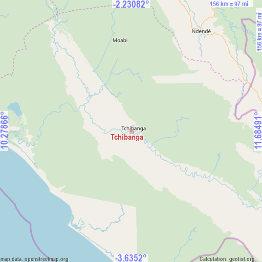
Tchibanga GPS coordinates[2]
2° 55' 59.628" South, 10° 58' 54.408" East
| Map corner | latitude | longitude |
|---|---|---|
| Upper-left | -2.23082°, | 10.27866° |
| Center: | -2.93323°, | 10.98178° |
| Lower-right: | -3.6352°, | 11.68491° |
| Map W x H: | 156.2×156.2 km | = 97.1×97.1mi |
| max Lat: | 2.07597° ⇑96.2% North |
| Tchibanga: | -2.93323° |
| min Lat: | ⇓3.8% South -3.43198° |
| min Long | Tchibanga | max Long |
| 8.78151° | 10.98178° | 14.25905° |
| W 38.5%⇐ | ⇒61.5% E |
Elevation
Elevation of Tchibanga is 49 m = 161 ft, and this is 208 m = 682 ft below average elevation for this country.
| Max E: |
667 m = 2188 ft | 69.2% |
| Avg. | 257 m = 843 ft | |
| Tchibanga | 49 m = 161 ft | |
Min E: |
4 m = 13 ft | 30.8% |
See also: Gabon elevation on elevation.city.
Geographical zone
Tchibanga is located in South Torrid zone (between Equator and Tropic of Capricorn). Distance of Equator is 326.1 km =202.6 mi to North.| Distance of | km | miles | from Tchibanga |
|---|---|---|---|
| Equator | 326.1 | 202.6 | to North |
| Tropic Capricorn | 2279.8 | 1416.6 | to South |
| Antarctic Circle | 7075 | 4396.2 | to South |
| South Pole | 9680.9 | 6015.4 | to South |


Nearby cities:
15 places around Tchibanga: (largest is in red/bold)
• Fougamou
196.1 km =121.9 mi,  346°
346°
• Franceville
323.2 km =200.8 mi,  63°
63°
• Gamba
113.5 km =70.5 mi,  286°
286°
• Koulamoutou
258.9 km =160.9 mi,  39°
39°
• Lambaréné
261.6 km =162.6 mi,  341°
341°
• Lastoursville
303.6 km =188.6 mi, 39°
• Mayumba
66.2 km =41.1 mi,  213°
213°
• Mbigou
154 km =95.7 mi, 41°
• Mimongo
161.7 km =100.5 mi,  25°
25°
• Moanda
289.4 km =179.8 mi, 58°
• Mouila
118.7 km =73.8 mi,  3°
3°
• Mounana
295.4 km =183.6 mi,  54°
54°
• Ndendé
72.5 km =45 mi, 35°
• Ndjolé
307.3 km =190.9 mi,  355°
355°
• Omboué
243.6 km =151.4 mi,  308°
308°
Sources, notices
• [Note1] Compared only with cities in Gabon existing in our database
• [Src1] Map data: © OpenStreetMap contributors (CC-BY-SA)
• [Src2] Other city data from geonames.org with taken over terms of usage.
• [Src3] Geographical zone / Annual Mean Temperature by Robert A. Rohde @ Wikipedia
