Mayumba geodata
Mayumba (Nyanga) is a populated place; located in Gabon in Africa/Libreville (GMT+1) time zone. With population of 3,996 people, there are 21 cities with bigger population in this country. Compared to other cities in Gabon, 100% of cities are located further ↑North; 69.2% of cities are located further →East and 84.6% of cities have higher elevation than Mayumba. Note1


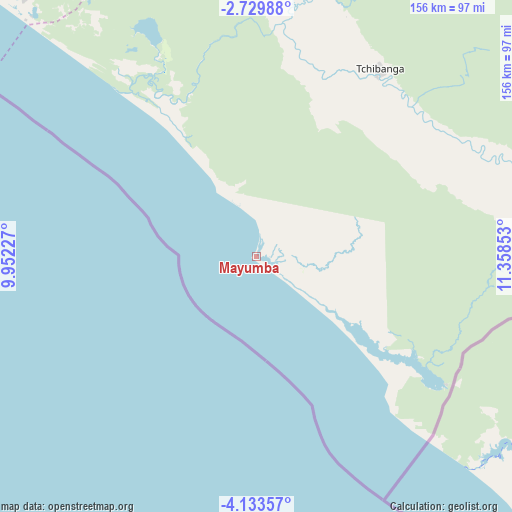
Mayumba GPS coordinates[2]
3° 25' 55.128" South, 10° 39' 19.44" East
| Map corner | latitude | longitude |
|---|---|---|
| Upper-left | -2.72988°, | 9.95227° |
| Center: | -3.43198°, | 10.6554° |
| Lower-right: | -4.13357°, | 11.35853° |
| Map W x H: | 156.1×156.1 km | = 97×97mi |
| max Lat: | 2.07597° ⇑100% North |
| Mayumba: | -3.43198° |
| min Lat: | ⇓0% South -3.43198° |
| min Long | Mayumba | max Long |
| 8.78151° | 10.6554° | 14.25905° |
| W 30.8%⇐ | ⇒69.2% E |
Elevation
Elevation of Mayumba is 17 m = 56 ft, and this is 240 m = 787 ft below average elevation for this country.
| Max E: |
667 m = 2188 ft | 84.6% |
| Avg. | 257 m = 843 ft | |
| Mayumba | 17 m = 56 ft | |
Min E: |
4 m = 13 ft | 15.4% |
See also: Gabon elevation on elevation.city.
Geographical zone
Mayumba is located in South Torrid zone (between Equator and Tropic of Capricorn). Distance of Equator is 381.6 km =237.1 mi to North.| Distance of | km | miles | from Mayumba |
|---|---|---|---|
| Equator | 381.6 | 237.1 | to North |
| Tropic Capricorn | 2224.3 | 1382.1 | to South |
| Antarctic Circle | 7019.6 | 4361.8 | to South |
| South Pole | 9625.5 | 5981 | to South |


Nearby cities:
15 places around Mayumba: (largest is in red/bold)
• Fougamou
246.6 km =153.2 mi,  358°
358°
• Gamba
113.4 km =70.5 mi,  320°
320°
• Koulamoutou
324.8 km =201.8 mi,  38°
38°
• Lambaréné
307.2 km =190.9 mi,  351°
351°
• Lastoursville
369.5 km =229.6 mi, 38°
• Mbigou
219.8 km =136.6 mi, 39°
• Mimongo
227.6 km =141.4 mi,  27°
27°
• Moanda
350.5 km =217.8 mi,  53°
53°
• Mouila
179.4 km =111.5 mi,  14°
14°
• Mounana
357.7 km =222.3 mi, 51°
• Ndendé
138.7 km =86.2 mi, 34°
• Ndjolé
362 km =224.9 mi,  1°
1°
• Omboué
258.1 km =160.4 mi, 323°
• Port-Gentil
366.5 km =227.7 mi,  325°
325°
• Tchibanga
66.2 km =41.1 mi, 33°
Sources, notices
• [Note1] Compared only with cities in Gabon existing in our database
• [Src1] Map data: © OpenStreetMap contributors (CC-BY-SA)
• [Src2] Other city data from geonames.org with taken over terms of usage.
• [Src3] Geographical zone / Annual Mean Temperature by Robert A. Rohde @ Wikipedia
