Takoradi geodata
Takoradi (Western) is a populated place; located in Ghana in Africa/Accra (GMT+0) time zone. With population of 232,919 people, there are 3 cities with bigger population in this country. Compared to other cities in Ghana, 98.6% of cities are located further ↑North; 79.2% of cities are located further →East and 66.7% of cities have higher elevation than Takoradi. Note1


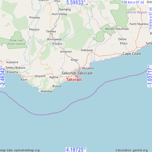
Takoradi GPS coordinates[2]
4° 53' 53.376" North, 1° 45' 37.044" West
| Map corner | latitude | longitude |
|---|---|---|
| Upper-left | 5.59833°, | -2.46342° |
| Center: | 4.89816°, | -1.76029° |
| Lower-right: | 4.19725°, | -1.05717° |
| Map W x H: | 155.8×155.8 km | = 96.8×96.8mi |
| max Lat: | 11.0616° ⇑98.6% North |
| Takoradi: | 4.89816° |
| min Lat: | ⇓1.4% South 4.86641° |
| min Long | Takoradi | max Long |
| -2.78516° | -1.76029° | 1.19012° |
| W 20.8%⇐ | ⇒79.2% E |
Elevation
Elevation of Takoradi is 74 m = 243 ft, and this is 96.2 m = 316 ft below average elevation for this country.
| Max E: |
477 m = 1565 ft | 66.7% |
| Avg. | 170.2 m = 558 ft | |
| Takoradi | 74 m = 243 ft | |
Min E: |
0 m = 0 ft | 33.3% |
See also: Takoradi elevation on elevation.city.
Geographical zone
Takoradi is located in North Torrid zone (between Equator and Tropic of Cancer). Distance of Equator is 544.6 km =338.4 mi to South.| Distance of | km | miles | from Takoradi |
|---|---|---|---|
| North Pole | 9462.4 | 5879.7 | to North |
| Arctic Circle | 6856.5 | 4260.4 | to North |
| Tropic Cancer | 2061.3 | 1280.8 | to North |
| Equator | 544.6 | 338.4 | to South |


Nearby cities:
15 places around Takoradi: (largest is in red/bold)
• Aboso
55.5 km =34.5 mi,  337°
337°
• Apam
121.2 km =75.3 mi,  69°
69°
• Axim
53.5 km =33.2 mi,  266°
266°
• Cape Coast
61.4 km =38.2 mi, 67°
• Dunkwa
118.1 km =73.4 mi,  359°
359°
• Elmina
49.9 km =31 mi, 65°
• Foso
103.6 km =64.4 mi,  30°
30°
• Mumford
118 km =73.3 mi, 69°
• Prestea
73.1 km =45.4 mi,  324°
324°
• Saltpond
84.9 km =52.8 mi, 65°
• Sekondi-Takoradi
3.2 km =2 mi,  5°
5°
• Shama Junction
17 km =10.6 mi,  38°
38°
• Tarkwa
51.8 km =32.2 mi,  330°
330°
• Wassa-Akropong
105.1 km =65.3 mi, 340°
• Winneba
135.6 km =84.3 mi, 68°
Sources, notices
• [Note1] Compared only with cities in Ghana existing in our database
• [Src1] Map data: © OpenStreetMap contributors (CC-BY-SA)
• [Src2] Other city data from geonames.org with taken over terms of usage.
• [Src3] Geographical zone / Annual Mean Temperature by Robert A. Rohde @ Wikipedia
