Sekondi-Takoradi geodata
Sekondi-Takoradi (Western) is a seat of a first-order administrative division; located in Ghana in Africa/Accra (GMT+0) time zone. With population of 138,872 people, there are 8 cities with bigger population in this country. Compared to other cities in Ghana, 97.2% of cities are located further ↑North; 77.8% of cities are located further →East and 69.4% of cities have higher elevation than Sekondi-Takoradi. Note1


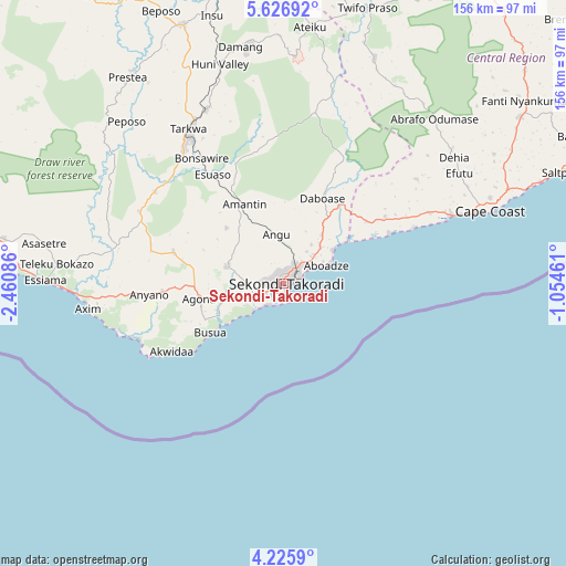
Sekondi-Takoradi GPS coordinates[2]
4° 55' 36.408" North, 1° 45' 27.828" West
| Map corner | latitude | longitude |
|---|---|---|
| Upper-left | 5.62692°, | -2.46086° |
| Center: | 4.92678°, | -1.75773° |
| Lower-right: | 4.2259°, | -1.05461° |
| Map W x H: | 155.8×155.8 km | = 96.8×96.8mi |
| max Lat: | 11.0616° ⇑97.2% North |
| Sekondi-Takoradi: | 4.92678° |
| min Lat: | ⇓2.8% South 4.86641° |
| min Long | Sekondi-Takorad | max Long |
| -2.78516° | -1.75773° | 1.19012° |
| W 22.2%⇐ | ⇒77.8% E |
Elevation
Elevation of Sekondi-Takoradi is 73 m = 240 ft, and this is 97.2 m = 319 ft below average elevation for this country.
| Max E: |
477 m = 1565 ft | 69.4% |
| Avg. | 170.2 m = 558 ft | |
| Sekondi-Takoradi | 73 m = 240 ft | |
Min E: |
0 m = 0 ft | 30.6% |
See also: Sekondi-Takoradi elevation on elevation.city.
Geographical zone
Sekondi-Takoradi is located in North Torrid zone (between Equator and Tropic of Cancer). Distance of Equator is 547.8 km =340.4 mi to South.| Distance of | km | miles | from Sekondi-Takoradi |
|---|---|---|---|
| North Pole | 9459.3 | 5877.7 | to North |
| Arctic Circle | 6853.4 | 4258.5 | to North |
| Tropic Cancer | 2058.1 | 1278.8 | to North |
| Equator | 547.8 | 340.4 | to South |


Nearby cities:
15 places around Sekondi-Takoradi: (largest is in red/bold)
• Aboso
52.7 km =32.7 mi,  336°
336°
• Apam
119.8 km =74.4 mi,  70°
70°
• Axim
54 km =33.6 mi,  262°
262°
• Cape Coast
60 km =37.3 mi, 70°
• Dunkwa
114.9 km =71.4 mi,  358°
358°
• Elmina
48.4 km =30.1 mi, 68°
• Foso
100.7 km =62.6 mi,  31°
31°
• Mumford
116.7 km =72.5 mi, 71°
• Prestea
70.7 km =43.9 mi,  322°
322°
• Saltpond
83.4 km =51.8 mi, 67°
• Shama Junction
14.5 km =9 mi,  45°
45°
• Takoradi
3.2 km =2 mi,  185°
185°
• Tarkwa
49.2 km =30.6 mi,  328°
328°
• Wassa-Akropong
102.2 km =63.5 mi, 339°
• Winneba
134.2 km =83.4 mi, 69°
Sources, notices
• [Note1] Compared only with cities in Ghana existing in our database
• [Src1] Map data: © OpenStreetMap contributors (CC-BY-SA)
• [Src2] Other city data from geonames.org with taken over terms of usage.
• [Src3] Geographical zone / Annual Mean Temperature by Robert A. Rohde @ Wikipedia
