Bawku geodata
Bawku (Upper East) is a populated place; located in Ghana in Africa/Accra (GMT+0) time zone. With population of 56,830 people, there are 22 cities with bigger population in this country. Compared to other cities in Ghana, 100% of cities are located further ↓South; 76.4% of cities are located further ←West and 73.6% of cities have lower elevation than Bawku. Note1


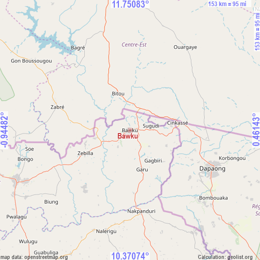
Bawku GPS coordinates[2]
11° 3' 41.76" North, 0° 14' 30.084" West
| Map corner | latitude | longitude |
|---|---|---|
| Upper-left | 11.75083°, | -0.94482° |
| Center: | 11.0616°, | -0.24169° |
| Lower-right: | 10.37074°, | 0.46143° |
| Map W x H: | 153.5×153.5 km | = 95.4×95.4mi |
| max Lat: | 11.0616° ⇑0% North |
| Bawku: | 11.0616° |
| min Lat: | ⇓100% South 4.86641° |
| min Long | Bawku | max Long |
| -2.78516° | -0.24169° | 1.19012° |
| W 76.4%⇐ | ⇒23.6% E |
Elevation
Elevation of Bawku is 252 m = 827 ft, and this is 81.8 m = 268 ft above average elevation for this country.
| Max E: |
477 m = 1565 ft | 26.4% |
| Bawku | 252 m 827 ft | |
| Avg. | 170.2 m = 558 ft | |
Min E: |
0 m = 0 ft | 73.6% |
See also: Bawku elevation on elevation.city.
Geographical zone
Bawku is located in North Torrid zone (between Equator and Tropic of Cancer). Distance of Equator is 1229.9 km =764.2 mi to South.| Distance of | km | miles | from Bawku |
|---|---|---|---|
| North Pole | 8777.1 | 5453.8 | to North |
| Arctic Circle | 6171.2 | 3834.6 | to North |
| Tropic Cancer | 1376 | 855 | to North |
| Equator | 1229.9 | 764.2 | to South |


Nearby cities:
14 places around Bawku: (largest is in red/bold)
• Bolgatanga
73.3 km =45.5 mi,  245°
245°
• Ejura
426.6 km =265.1 mi,  196°
196°
• Hohoe
441.8 km =274.5 mi,  169°
169°
• Kete Krachi
363.9 km =226.1 mi,  176°
176°
• Kintampo
371.9 km =231.1 mi,  206°
206°
• Kpandae
289.4 km =179.8 mi, 174°
• Navrongo
94.6 km =58.8 mi,  258°
258°
• Salaga
280.8 km =174.5 mi,  186°
186°
• Savelugu
172.1 km =106.9 mi, 201°
• Tamale
195.9 km =121.7 mi, 199°
• Techiman
429.1 km =266.6 mi, 205°
• Wa
271 km =168.4 mi, 245°
• Wenchi
422.2 km =262.3 mi, 208°
• Yendi
181.8 km =113 mi, 171°
Sources, notices
• [Note1] Compared only with cities in Ghana existing in our database
• [Src1] Map data: © OpenStreetMap contributors (CC-BY-SA)
• [Src2] Other city data from geonames.org with taken over terms of usage.
• [Src3] Geographical zone / Annual Mean Temperature by Robert A. Rohde @ Wikipedia
