Navrongo geodata
Navrongo (Upper East) is a populated place; located in Ghana in Africa/Accra (GMT+0) time zone. With population of 25,470 people, there are 49 cities with bigger population in this country. Compared to other cities in Ghana, 98.6% of cities are located further ↓South; 58.3% of cities are located further →East and 62.5% of cities have lower elevation than Navrongo. Note1


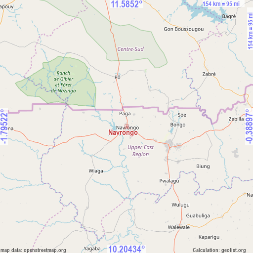
Navrongo GPS coordinates[2]
10° 53' 44.052" North, 1° 5' 31.56" West
| Map corner | latitude | longitude |
|---|---|---|
| Upper-left | 11.5852°, | -1.79522° |
| Center: | 10.89557°, | -1.0921° |
| Lower-right: | 10.20434°, | -0.38897° |
| Map W x H: | 153.5×153.5 km | = 95.4×95.4mi |
| max Lat: | 11.0616° ⇑1.4% North |
| Navrongo: | 10.89557° |
| min Lat: | ⇓98.6% South 4.86641° |
| min Long | Navrongo | max Long |
| -2.78516° | -1.0921° | 1.19012° |
| W 41.7%⇐ | ⇒58.3% E |
Elevation
Elevation of Navrongo is 198 m = 650 ft, and this is 27.8 m = 91 ft above average elevation for this country.
| Max E: |
477 m = 1565 ft | 37.5% |
| Navrongo | 198 m 650 ft | |
| Avg. | 170.2 m = 558 ft | |
Min E: |
0 m = 0 ft | 62.5% |
See also: Ghana elevation on elevation.city.
Geographical zone
Navrongo is located in North Torrid zone (between Equator and Tropic of Cancer). Distance of Equator is 1211.5 km =752.8 mi to South.| Distance of | km | miles | from Navrongo |
|---|---|---|---|
| North Pole | 8795.6 | 5465.3 | to North |
| Arctic Circle | 6189.7 | 3846.1 | to North |
| Tropic Cancer | 1394.4 | 866.4 | to North |
| Equator | 1211.5 | 752.8 | to South |


Nearby cities:
15 places around Navrongo: (largest is in red/bold)
• Bawku
94.6 km =58.8 mi,  78°
78°
• Berekum
416.3 km =258.7 mi,  203°
203°
• Bolgatanga
29 km =18 mi,  114°
114°
• Ejura
391.3 km =243.1 mi,  184°
184°
• Japekrom
413.2 km =256.8 mi,  206°
206°
• Kete Krachi
363.3 km =225.7 mi,  161°
161°
• Kintampo
323.4 km =201 mi,  192°
192°
• Kpandae
294.7 km =183.1 mi, 156°
• Salaga
268.2 km =166.7 mi,  166°
166°
• Savelugu
144.3 km =89.7 mi, 168°
• Tamale
168.5 km =104.7 mi, 170°
• Techiman
379.7 km =235.9 mi, 194°
• Wa
179.9 km =111.8 mi,  238°
238°
• Wenchi
368.1 km =228.7 mi, 197°
• Yendi
200.3 km =124.5 mi,  143°
143°
Sources, notices
• [Note1] Compared only with cities in Ghana existing in our database
• [Src1] Map data: © OpenStreetMap contributors (CC-BY-SA)
• [Src2] Other city data from geonames.org with taken over terms of usage.
• [Src3] Geographical zone / Annual Mean Temperature by Robert A. Rohde @ Wikipedia
