Wa geodata
Wa (Upper West) is a seat of a first-order administrative division; located in Ghana in Africa/Accra (GMT+0) time zone. With population of 78,107 people, there are 13 cities with bigger population in this country. Compared to other cities in Ghana, 95.8% of cities are located further ↓South; 97.2% of cities are located further →East and 87.5% of cities have lower elevation than Wa. Note1


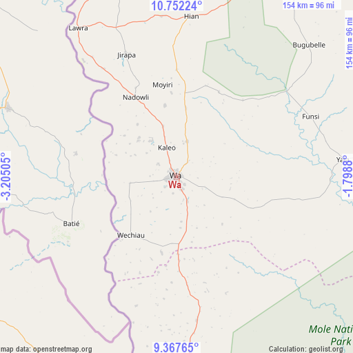
Wa GPS coordinates[2]
10° 3' 38.484" North, 2° 30' 6.912" West
| Map corner | latitude | longitude |
|---|---|---|
| Upper-left | 10.75224°, | -3.20505° |
| Center: | 10.06069°, | -2.50192° |
| Lower-right: | 9.36765°, | -1.7988° |
| Map W x H: | 154×154 km | = 95.7×95.7mi |
| max Lat: | 11.0616° ⇑4.2% North |
| Wa: | 10.06069° |
| min Lat: | ⇓95.8% South 4.86641° |
| min Long | Wa | max Long |
| -2.78516° | -2.50192° | 1.19012° |
| W 2.8%⇐ | ⇒97.2% E |
Elevation
Elevation of Wa is 326 m = 1070 ft, and this is 155.8 m = 511 ft above average elevation for this country.
| Max E: |
477 m = 1565 ft | 12.5% |
| Wa | 326 m 1070 ft | |
| Avg. | 170.2 m = 558 ft | |
Min E: |
0 m = 0 ft | 87.5% |
See also: Wa elevation on elevation.city.
Geographical zone
Wa is located in North Torrid zone (between Equator and Tropic of Cancer). Distance of Equator is 1118.6 km =695.1 mi to South.| Distance of | km | miles | from Wa |
|---|---|---|---|
| North Pole | 8888.4 | 5523 | to North |
| Arctic Circle | 6282.5 | 3903.8 | to North |
| Tropic Cancer | 1487.3 | 924.2 | to North |
| Equator | 1118.6 | 695.1 | to South |


Nearby cities:
15 places around Wa: (largest is in red/bold)
• Bawku
271 km =168.4 mi,  65°
65°
• Berekum
290 km =180.2 mi,  181°
181°
• Bolgatanga
197.7 km =122.8 mi, 65°
• Duayaw-Nkwanta
323.9 km =201.3 mi,  172°
172°
• Ejura
323 km =200.7 mi,  157°
157°
• Japekrom
278 km =172.7 mi,  186°
186°
• Kintampo
238.4 km =148.1 mi, 159°
• Navrongo
179.9 km =111.8 mi,  58°
58°
• Salaga
274.8 km =170.8 mi,  127°
127°
• Savelugu
190 km =118.1 mi,  104°
104°
• Sunyani
303.1 km =188.3 mi, 176°
• Tamale
196.4 km =122 mi,  111°
111°
• Techiman
282.2 km =175.4 mi, 167°
• Wenchi
261.8 km =162.7 mi, 170°
• Yendi
281.6 km =175 mi, 104°
Sources, notices
• [Note1] Compared only with cities in Ghana existing in our database
• [Src1] Map data: © OpenStreetMap contributors (CC-BY-SA)
• [Src2] Other city data from geonames.org with taken over terms of usage.
• [Src3] Geographical zone / Annual Mean Temperature by Robert A. Rohde @ Wikipedia
