Tondon geodata
Tondon (Kindia) is a populated place; located in Guinea in Africa/Conakry (GMT+0) time zone. With population of 12,235 people, there are 21 cities with bigger population in this country. Compared to other cities in Guinea, 56.4% of cities are located further ↑North; 76.9% of cities are located further →East and 71.8% of cities have higher elevation than Tondon. Note1


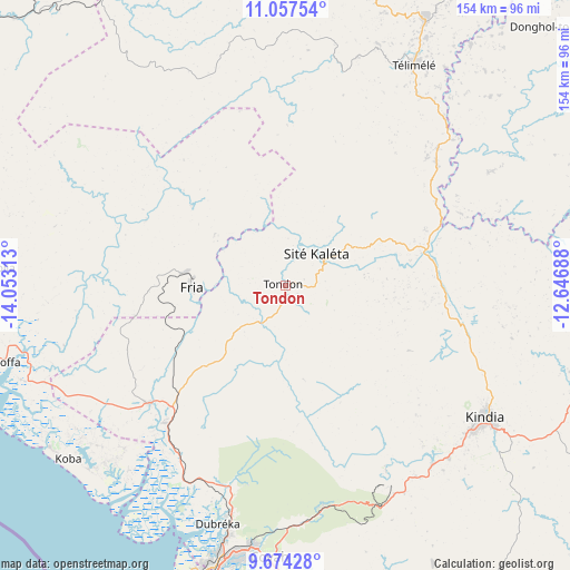
Tondon GPS coordinates[2]
10° 22' 0.012" North, 13° 21' 0" West
| Map corner | latitude | longitude |
|---|---|---|
| Upper-left | 11.05754°, | -14.05313° |
| Center: | 10.36667°, | -13.35° |
| Lower-right: | 9.67428°, | -12.64688° |
| Map W x H: | 153.8×153.8 km | = 95.6×95.6mi |
| max Lat: | 12.5311° ⇑56.4% North |
| Tondon: | 10.36667° |
| min Lat: | ⇓43.6% South 7.56748° |
| min Long | Tondon | max Long |
| -14.36667° | -13.35° | -8.53333° |
| W 23.1%⇐ | ⇒76.9% E |
Elevation
Elevation of Tondon is 113 m = 371 ft, and this is 320.4 m = 1051 ft below average elevation for this country.
| Max E: |
1440 m = 4724 ft | 71.8% |
| Avg. | 433.4 m = 1422 ft | |
| Tondon | 113 m = 371 ft | |
Min E: |
0 m = 0 ft | 28.2% |
See also: Guinea elevation on elevation.city.
Geographical zone
Tondon is located in North Torrid zone (between Equator and Tropic of Cancer). Distance of Equator is 1152.7 km =716.3 mi to South.| Distance of | km | miles | from Tondon |
|---|---|---|---|
| North Pole | 8854.4 | 5501.9 | to North |
| Arctic Circle | 6248.5 | 3882.6 | to North |
| Tropic Cancer | 1453.3 | 903 | to North |
| Equator | 1152.7 | 716.3 | to South |


Nearby cities:
15 places around Tondon: (largest is in red/bold)
• Boffa
78 km =48.5 mi,  253°
253°
• Boké
120.5 km =74.9 mi,  301°
301°
• Camayenne
99.6 km =61.9 mi,  201°
201°
• Conakry
98.9 km =61.5 mi, 201°
• Coyah
73.5 km =45.7 mi,  182°
182°
• Dalaba
125.6 km =78 mi,  73°
73°
• Dubréka
66.8 km =41.5 mi, 196°
• Forécariah
108 km =67.1 mi,  164°
164°
• Fria
25.4 km =15.8 mi,  270°
270°
• Kimbo
22.2 km =13.8 mi,  279°
279°
• Kindia
63.2 km =39.3 mi,  123°
123°
• Mamou
137.7 km =85.6 mi,  89°
89°
• Pita
129.7 km =80.6 mi,  53°
53°
• Sanguéya
117.2 km =72.8 mi,  288°
288°
• Télimélé
68.7 km =42.7 mi,  30°
30°
Sources, notices
• [Note1] Compared only with cities in Guinea existing in our database
• [Src1] Map data: © OpenStreetMap contributors (CC-BY-SA)
• [Src2] Other city data from geonames.org with taken over terms of usage.
• [Src3] Geographical zone / Annual Mean Temperature by Robert A. Rohde @ Wikipedia
