Boké geodata
Boké (Boke) is a seat of a first-order administrative division; located in Guinea in Africa/Conakry (GMT+0) time zone. With population of 15,460 people, there are 16 cities with bigger population in this country. Compared to other cities in Guinea, 71.8% of cities are located further ↓South; 97.4% of cities are located further →East and 82.1% of cities have higher elevation than Boké. Note1


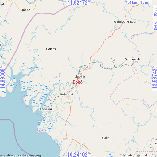
Boké GPS coordinates[2]
10° 55' 55.812" North, 14° 17' 25.98" West
| Map corner | latitude | longitude |
|---|---|---|
| Upper-left | 11.62172°, | -14.99368° |
| Center: | 10.93217°, | -14.29055° |
| Lower-right: | 10.24102°, | -13.58743° |
| Map W x H: | 153.5×153.5 km | = 95.4×95.4mi |
| max Lat: | 12.5311° ⇑28.2% North |
| Boké: | 10.93217° |
| min Lat: | ⇓71.8% South 7.56748° |
| min Long | Boké | max Long |
| -14.36667° | -14.29055° | -8.53333° |
| W 2.6%⇐ | ⇒97.4% E |
Elevation
Elevation of Boké is 49 m = 161 ft, and this is 384.4 m = 1261 ft below average elevation for this country.
| Max E: |
1440 m = 4724 ft | 82.1% |
| Avg. | 433.4 m = 1422 ft | |
| Boké | 49 m = 161 ft | |
Min E: |
0 m = 0 ft | 17.9% |
See also: Guinea elevation on elevation.city.
Geographical zone
Boké is located in North Torrid zone (between Equator and Tropic of Cancer). Distance of Equator is 1215.5 km =755.3 mi to South.| Distance of | km | miles | from Boké |
|---|---|---|---|
| North Pole | 8791.5 | 5462.8 | to North |
| Arctic Circle | 6185.6 | 3843.6 | to North |
| Tropic Cancer | 1390.4 | 864 | to North |
| Equator | 1215.5 | 755.3 | to South |


Nearby cities:
15 places around Boké: (largest is in red/bold)
• Boffa
89.6 km =55.7 mi,  161°
161°
• Camayenne
168.8 km =104.9 mi, 156°
• Conakry
168.9 km =104.9 mi, 156°
• Coyah
168.5 km =104.7 mi,  143°
143°
• Dubréka
152.1 km =94.5 mi,  146°
146°
• Fria
99.7 km =62 mi,  129°
129°
• Gaoual
149.7 km =93 mi,  52°
52°
• Kimbo
100.2 km =62.3 mi, 126°
• Kindia
183.7 km =114.1 mi,  121°
121°
• Koundara
203.4 km =126.4 mi,  32°
32°
• Lélouma
183.8 km =114.2 mi,  72°
72°
• Pita
207.4 km =128.9 mi,  86°
86°
• Sanguéya
27.1 km =16.8 mi,  197°
197°
• Tondon
120.5 km =74.9 mi, 121°
• Télimélé
137.3 km =85.3 mi, 91°
Sources, notices
• [Note1] Compared only with cities in Guinea existing in our database
• [Src1] Map data: © OpenStreetMap contributors (CC-BY-SA)
• [Src2] Other city data from geonames.org with taken over terms of usage.
• [Src3] Geographical zone / Annual Mean Temperature by Robert A. Rohde @ Wikipedia
