Kindia geodata
Kindia is a seat of a first-order administrative division; located in Guinea in Africa/Conakry (GMT+0) time zone. With population of 117,062 people, there are 3 cities with bigger population in this country. Compared to other cities in Guinea, 61.5% of cities are located further ↑North; 61.5% of cities are located further →East and 51.3% of cities have higher elevation than Kindia. Note1


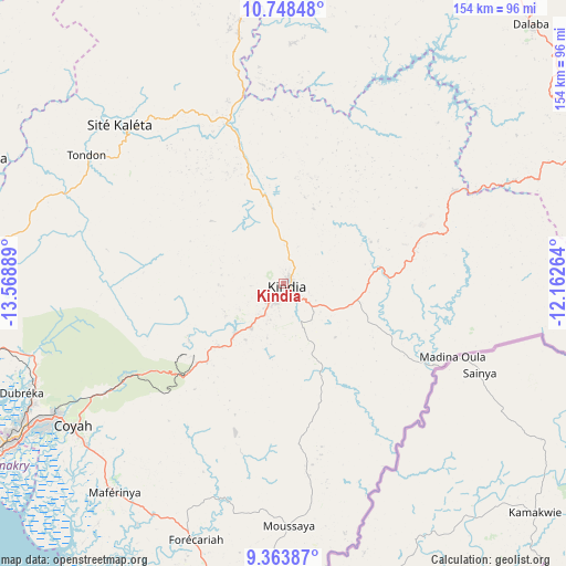
Kindia GPS coordinates[2]
10° 3' 24.912" North, 12° 51' 56.736" West
| Map corner | latitude | longitude |
|---|---|---|
| Upper-left | 10.74848°, | -13.56889° |
| Center: | 10.05692°, | -12.86576° |
| Lower-right: | 9.36387°, | -12.16264° |
| Map W x H: | 154×154 km | = 95.7×95.7mi |
| max Lat: | 12.5311° ⇑61.5% North |
| Kindia: | 10.05692° |
| min Lat: | ⇓38.5% South 7.56748° |
| min Long | Kindia | max Long |
| -14.36667° | -12.86576° | -8.53333° |
| W 38.5%⇐ | ⇒61.5% E |
Elevation
Elevation of Kindia is 415 m = 1362 ft, and this is 18.4 m = 60 ft below average elevation for this country.
| Max E: |
1440 m = 4724 ft | 51.3% |
| Avg. | 433.4 m = 1422 ft | |
| Kindia | 415 m = 1362 ft | |
Min E: |
0 m = 0 ft | 48.7% |
See also: Kindia elevation on elevation.city.
Geographical zone
Kindia is located in North Torrid zone (between Equator and Tropic of Cancer). Distance of Equator is 1118.2 km =694.8 mi to South.| Distance of | km | miles | from Kindia |
|---|---|---|---|
| North Pole | 8888.8 | 5523.2 | to North |
| Arctic Circle | 6282.9 | 3904 | to North |
| Tropic Cancer | 1487.7 | 924.4 | to North |
| Equator | 1118.2 | 694.8 | to South |


Nearby cities:
15 places around Kindia: (largest is in red/bold)
• Boffa
128.4 km =79.8 mi,  275°
275°
• Camayenne
107.1 km =66.5 mi,  237°
237°
• Conakry
106 km =65.9 mi, 237°
• Coyah
68.9 km =42.8 mi, 235°
• Dalaba
97.6 km =60.6 mi,  43°
43°
• Dubréka
77.8 km =48.3 mi,  247°
247°
• Forécariah
73.8 km =45.9 mi,  199°
199°
• Fria
85.7 km =53.3 mi,  293°
293°
• Kimbo
84 km =52.2 mi,  296°
296°
• Labé
154 km =95.7 mi,  24°
24°
• Lélouma
153.3 km =95.3 mi,  7°
7°
• Mamou
91.8 km =57 mi,  67°
67°
• Pita
122.7 km =76.2 mi, 24°
• Tondon
63.2 km =39.3 mi, 303°
• Télimélé
95.5 km =59.3 mi,  348°
348°
Sources, notices
• [Note1] Compared only with cities in Guinea existing in our database
• [Src1] Map data: © OpenStreetMap contributors (CC-BY-SA)
• [Src2] Other city data from geonames.org with taken over terms of usage.
• [Src3] Geographical zone / Annual Mean Temperature by Robert A. Rohde @ Wikipedia
