Coyah geodata
Coyah (Kindia) is a seat of a second-order administrative division; located in Guinea in Africa/Conakry (GMT+0) time zone. With population of 77,103 people, there are 6 cities with bigger population in this country. Compared to other cities in Guinea, 69.2% of cities are located further ↑North; 79.5% of cities are located further →East and 94.9% of cities have higher elevation than Coyah. Note1


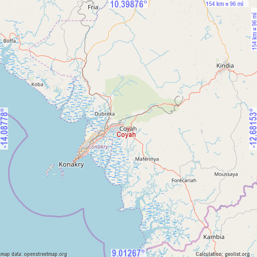
Coyah GPS coordinates[2]
9° 42' 23.148" North, 13° 23' 4.74" West
| Map corner | latitude | longitude |
|---|---|---|
| Upper-left | 10.39876°, | -14.08778° |
| Center: | 9.70643°, | -13.38465° |
| Lower-right: | 9.01267°, | -12.68153° |
| Map W x H: | 154.1×154.1 km | = 95.8×95.8mi |
| max Lat: | 12.5311° ⇑69.2% North |
| Coyah: | 9.70643° |
| min Lat: | ⇓30.8% South 7.56748° |
| min Long | Coyah | max Long |
| -14.36667° | -13.38465° | -8.53333° |
| W 20.5%⇐ | ⇒79.5% E |
Elevation
Elevation of Coyah is 13 m = 43 ft, and this is 420.4 m = 1379 ft below average elevation for this country.
| Max E: |
1440 m = 4724 ft | 94.9% |
| Avg. | 433.4 m = 1422 ft | |
| Coyah | 13 m = 43 ft | |
Min E: |
0 m = 0 ft | 5.1% |
See also: Coyah elevation on elevation.city.
Geographical zone
Coyah is located in North Torrid zone (between Equator and Tropic of Cancer). Distance of Equator is 1079.3 km =670.6 mi to South.| Distance of | km | miles | from Coyah |
|---|---|---|---|
| North Pole | 8927.8 | 5547.5 | to North |
| Arctic Circle | 6321.9 | 3928.2 | to North |
| Tropic Cancer | 1526.7 | 948.6 | to North |
| Equator | 1079.3 | 670.6 | to South |


Nearby cities:
15 places around Coyah: (largest is in red/bold)
• Boffa
87.6 km =54.4 mi,  305°
305°
• Boké
168.5 km =104.7 mi,  323°
323°
• Camayenne
38.3 km =23.8 mi,  240°
240°
• Conakry
37.1 km =23.1 mi, 239°
• Dalaba
165.7 km =103 mi,  48°
48°
• Dubréka
17.9 km =11.1 mi,  301°
301°
• Forécariah
44.7 km =27.8 mi,  133°
133°
• Fria
76.6 km =47.6 mi,  343°
343°
• Kimbo
79.2 km =49.2 mi,  346°
346°
• Kindia
68.9 km =42.8 mi,  55°
55°
• Mamou
159.9 km =99.4 mi, 62°
• Pita
185.3 km =115.1 mi,  35°
35°
• Sanguéya
154.1 km =95.8 mi, 315°
• Tondon
73.5 km =45.7 mi,  2°
2°
• Télimélé
138.2 km =85.9 mi,  16°
16°
Sources, notices
• [Note1] Compared only with cities in Guinea existing in our database
• [Src1] Map data: © OpenStreetMap contributors (CC-BY-SA)
• [Src2] Other city data from geonames.org with taken over terms of usage.
• [Src3] Geographical zone / Annual Mean Temperature by Robert A. Rohde @ Wikipedia
