Boffa geodata
Boffa (Boke) is a seat of a second-order administrative division; located in Guinea in Africa/Conakry (GMT+0) time zone. With population of 2,332 people, there are 38 cities with bigger population in this country. Compared to other cities in Guinea, 59% of cities are located further ↑North; 94.9% of cities are located further →East and 100% of cities have higher elevation than Boffa. Note1


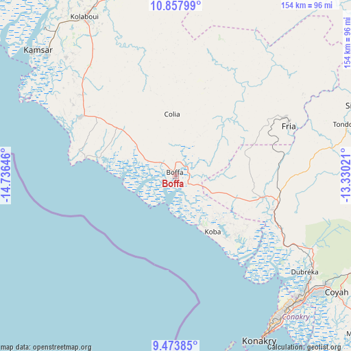
Boffa GPS coordinates[2]
10° 10' 0.012" North, 14° 1' 59.988" West
| Map corner | latitude | longitude |
|---|---|---|
| Upper-left | 10.85799°, | -14.73646° |
| Center: | 10.16667°, | -14.03333° |
| Lower-right: | 9.47385°, | -13.33021° |
| Map W x H: | 153.9×153.9 km | = 95.6×95.6mi |
| max Lat: | 12.5311° ⇑59% North |
| Boffa: | 10.16667° |
| min Lat: | ⇓41% South 7.56748° |
| min Long | Boffa | max Long |
| -14.36667° | -14.03333° | -8.53333° |
| W 5.1%⇐ | ⇒94.9% E |
Elevation
Elevation of Boffa is 0 m = 0 ft, and this is 433.4 m = 1422 ft below average elevation for this country.
| Max E: |
1440 m = 4724 ft | 100% |
| Avg. | 433.4 m = 1422 ft | |
| Boffa | 0 m = 0 ft | |
Min E: |
0 m = 0 ft | 0% |
See also: Guinea elevation on elevation.city.
Geographical zone
Boffa is located in North Torrid zone (between Equator and Tropic of Cancer). Distance of Equator is 1130.4 km =702.4 mi to South.| Distance of | km | miles | from Boffa |
|---|---|---|---|
| North Pole | 8876.6 | 5515.7 | to North |
| Arctic Circle | 6270.7 | 3896.4 | to North |
| Tropic Cancer | 1475.5 | 916.8 | to North |
| Equator | 1130.4 | 702.4 | to South |


Nearby cities:
15 places around Boffa: (largest is in red/bold)
• Boké
89.6 km =55.7 mi,  341°
341°
• Camayenne
79.8 km =49.6 mi,  151°
151°
• Conakry
80.1 km =49.8 mi, 150°
• Coyah
87.6 km =54.4 mi,  125°
125°
• Dalaba
203.6 km =126.5 mi,  73°
73°
• Dubréka
69.7 km =43.3 mi, 126°
• Forécariah
132 km =82 mi, 128°
• Fria
54.1 km =33.6 mi, 65°
• Gaoual
198.2 km =123.2 mi,  27°
27°
• Kimbo
58.9 km =36.6 mi,  63°
63°
• Kindia
128.4 km =79.8 mi,  95°
95°
• Lélouma
203.3 km =126.3 mi,  46°
46°
• Sanguéya
69.6 km =43.2 mi,  328°
328°
• Tondon
78 km =48.5 mi, 73°
• Télimélé
136.4 km =84.8 mi, 53°
Sources, notices
• [Note1] Compared only with cities in Guinea existing in our database
• [Src1] Map data: © OpenStreetMap contributors (CC-BY-SA)
• [Src2] Other city data from geonames.org with taken over terms of usage.
• [Src3] Geographical zone / Annual Mean Temperature by Robert A. Rohde @ Wikipedia
