Forécariah geodata
Forécariah (Kindia) is a seat of a second-order administrative division; located in Guinea in Africa/Conakry (GMT+0) time zone. With population of 12,358 people, there are 20 cities with bigger population in this country. Compared to other cities in Guinea, 79.5% of cities are located further ↑North; 66.7% of cities are located further →East and 84.6% of cities have higher elevation than Forécariah. Note1


Forécariah GPS coordinates[2]
9° 25' 50.016" North, 13° 5' 17.016" West
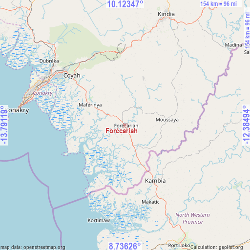
| Map corner | latitude | longitude |
|---|---|---|
| Upper-left | 10.12347°, | -13.79119° |
| Center: | 9.43056°, | -13.08806° |
| Lower-right: | 8.73626°, | -12.38494° |
| Map W x H: | 154.2×154.2 km | = 95.8×95.8mi |
| max Lat: | 12.5311° ⇑79.5% North |
| Forécariah: | 9.43056° |
| min Lat: | ⇓20.5% South 7.56748° |
| min Long | Forécariah | max Long |
| -14.36667° | -13.08806° | -8.53333° |
| W 33.3%⇐ | ⇒66.7% E |
Elevation
Elevation of Forécariah is 32 m = 105 ft, and this is 401.4 m = 1317 ft below average elevation for this country.
| Max E: |
1440 m = 4724 ft | 84.6% |
| Avg. | 433.4 m = 1422 ft | |
| Forécariah | 32 m = 105 ft | |
Min E: |
0 m = 0 ft | 15.4% |
See also: Guinea elevation on elevation.city.
Geographical zone
Forécariah is located in North Torrid zone (between Equator and Tropic of Cancer). Distance of Equator is 1048.6 km =651.6 mi to South.| Distance of | km | miles | from Forécariah |
|---|---|---|---|
| North Pole | 8958.5 | 5566.6 | to North |
| Arctic Circle | 6352.6 | 3947.3 | to North |
| Tropic Cancer | 1557.3 | 967.7 | to North |
| Equator | 1048.6 | 651.6 | to South |


Nearby cities:
15 places around Forécariah: (largest is in red/bold)
• Boffa
132 km =82 mi,  308°
308°
• Boké
212.6 km =132.1 mi,  321°
321°
• Camayenne
66.8 km =41.5 mi,  280°
280°
• Conakry
65.7 km =40.8 mi, 280°
• Coyah
44.7 km =27.8 mi, 313°
• Dalaba
167.7 km =104.2 mi,  33°
33°
• Dubréka
62.3 km =38.7 mi, 310°
• Fria
117.3 km =72.9 mi,  332°
332°
• Kimbo
119.1 km =74 mi, 334°
• Kindia
73.8 km =45.9 mi,  19°
19°
• Mamou
151.5 km =94.1 mi,  46°
46°
• Pita
196.3 km =122 mi, 22°
• Sanguéya
198.8 km =123.5 mi, 315°
• Tondon
108 km =67.1 mi,  344°
344°
• Télimélé
163.5 km =101.6 mi,  2°
2°
Sources, notices
• [Note1] Compared only with cities in Guinea existing in our database
• [Src1] Map data: © OpenStreetMap contributors (CC-BY-SA)
• [Src2] Other city data from geonames.org with taken over terms of usage.
• [Src3] Geographical zone / Annual Mean Temperature by Robert A. Rohde @ Wikipedia
