Mamou geodata
Mamou is a seat of a first-order administrative division; located in Guinea in Africa/Conakry (GMT+0) time zone. With population of 41,619 people, there are 12 cities with bigger population in this country. Compared to other cities in Guinea, 51.3% of cities are located further ↑North; 53.8% of cities are located further ←West and 82.1% of cities have lower elevation than Mamou. Note1


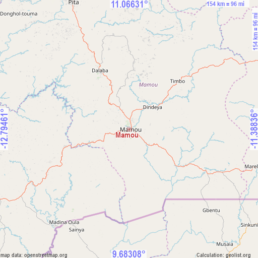
Mamou GPS coordinates[2]
10° 22' 31.656" North, 12° 5' 29.328" West
| Map corner | latitude | longitude |
|---|---|---|
| Upper-left | 11.06631°, | -12.79461° |
| Center: | 10.37546°, | -12.09148° |
| Lower-right: | 9.68308°, | -11.38836° |
| Map W x H: | 153.8×153.8 km | = 95.6×95.6mi |
| max Lat: | 12.5311° ⇑51.3% North |
| Mamou: | 10.37546° |
| min Lat: | ⇓48.7% South 7.56748° |
| min Long | Mamou | max Long |
| -14.36667° | -12.09148° | -8.53333° |
| W 53.8%⇐ | ⇒46.2% E |
Elevation
Elevation of Mamou is 720 m = 2362 ft, and this is 286.6 m = 940 ft above average elevation for this country.
| Max E: |
1440 m = 4724 ft | 17.9% |
| Mamou | 720 m 2362 ft | |
| Avg. | 433.4 m = 1422 ft | |
Min E: |
0 m = 0 ft | 82.1% |
See also: Mamou elevation on elevation.city.
Geographical zone
Mamou is located in North Torrid zone (between Equator and Tropic of Cancer). Distance of Equator is 1153.6 km =716.8 mi to South.| Distance of | km | miles | from Mamou |
|---|---|---|---|
| North Pole | 8853.4 | 5501.2 | to North |
| Arctic Circle | 6247.5 | 3882 | to North |
| Tropic Cancer | 1452.3 | 902.4 | to North |
| Equator | 1153.6 | 716.8 | to South |


Nearby cities:
15 places around Mamou: (largest is in red/bold)
• Coyah
159.9 km =99.4 mi,  242°
242°
• Dabola
115 km =71.5 mi,  69°
69°
• Dalaba
39.3 km =24.4 mi,  333°
333°
• Faranah
152.1 km =94.5 mi,  104°
104°
• Forécariah
151.5 km =94.1 mi,  226°
226°
• Fria
163.1 km =101.3 mi,  269°
269°
• Kimbo
159.5 km =99.1 mi, 270°
• Kindia
91.8 km =57 mi,  247°
247°
• Koubia
136.3 km =84.7 mi,  9°
9°
• Labé
106.9 km =66.4 mi,  348°
348°
• Lélouma
133.2 km =82.8 mi, 331°
• Pita
82.9 km =51.5 mi,  336°
336°
• Tondon
137.7 km =85.6 mi, 269°
• Tougué
127.7 km =79.3 mi,  21°
21°
• Télimélé
118.3 km =73.5 mi,  299°
299°
Sources, notices
• [Note1] Compared only with cities in Guinea existing in our database
• [Src1] Map data: © OpenStreetMap contributors (CC-BY-SA)
• [Src2] Other city data from geonames.org with taken over terms of usage.
• [Src3] Geographical zone / Annual Mean Temperature by Robert A. Rohde @ Wikipedia
