Pita geodata
Pita (Mamou) is a seat of a second-order administrative division; located in Guinea in Africa/Conakry (GMT+0) time zone. With population of 20,052 people, there are 15 cities with bigger population in this country. Compared to other cities in Guinea, 74.4% of cities are located further ↓South; 56.4% of cities are located further →East and 92.3% of cities have lower elevation than Pita. Note1


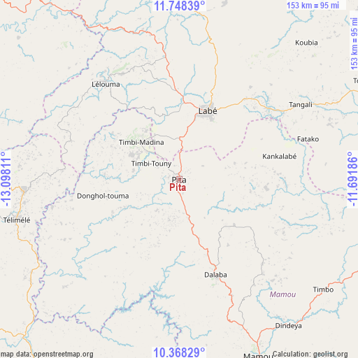
Pita GPS coordinates[2]
11° 3' 32.94" North, 12° 23' 41.928" West
| Map corner | latitude | longitude |
|---|---|---|
| Upper-left | 11.74839°, | -13.09811° |
| Center: | 11.05915°, | -12.39498° |
| Lower-right: | 10.36829°, | -11.69186° |
| Map W x H: | 153.5×153.5 km | = 95.4×95.4mi |
| max Lat: | 12.5311° ⇑25.6% North |
| Pita: | 11.05915° |
| min Lat: | ⇓74.4% South 7.56748° |
| min Long | Pita | max Long |
| -14.36667° | -12.39498° | -8.53333° |
| W 43.6%⇐ | ⇒56.4% E |
Elevation
Elevation of Pita is 973 m = 3192 ft, and this is 539.6 m = 1770 ft above average elevation for this country.
| Max E: |
1440 m = 4724 ft | 7.7% |
| Pita | 973 m 3192 ft | |
| Avg. | 433.4 m = 1422 ft | |
Min E: |
0 m = 0 ft | 92.3% |
See also: Guinea elevation on elevation.city.
Geographical zone
Pita is located in North Torrid zone (between Equator and Tropic of Cancer). Distance of Equator is 1229.7 km =764.1 mi to South.| Distance of | km | miles | from Pita |
|---|---|---|---|
| North Pole | 8777.4 | 5454 | to North |
| Arctic Circle | 6171.5 | 3834.8 | to North |
| Tropic Cancer | 1376.3 | 855.2 | to North |
| Equator | 1229.7 | 764.1 | to South |


Nearby cities:
15 places around Pita: (largest is in red/bold)
• Dabola
144.9 km =90 mi,  104°
104°
• Dalaba
43.7 km =27.2 mi,  158°
158°
• Fria
150.9 km =93.8 mi,  239°
239°
• Gaoual
116.6 km =72.5 mi,  311°
311°
• Kimbo
145.9 km =90.7 mi, 239°
• Kindia
122.7 km =76.2 mi,  204°
204°
• Koubia
80.1 km =49.8 mi,  42°
42°
• Labé
31.3 km =19.4 mi,  22°
22°
• Lélouma
51.2 km =31.8 mi,  322°
322°
• Mali
113.9 km =70.8 mi,  5°
5°
• Mamou
82.9 km =51.5 mi, 156°
• Tondon
129.7 km =80.6 mi,  233°
233°
• Tougué
90.5 km =56.2 mi,  61°
61°
• Télimélé
71.9 km =44.7 mi,  255°
255°
• Youkounkoun
181.8 km =113 mi,  334°
334°
Sources, notices
• [Note1] Compared only with cities in Guinea existing in our database
• [Src1] Map data: © OpenStreetMap contributors (CC-BY-SA)
• [Src2] Other city data from geonames.org with taken over terms of usage.
• [Src3] Geographical zone / Annual Mean Temperature by Robert A. Rohde @ Wikipedia
