Télimélé geodata
Télimélé (Kindia) is a seat of a second-order administrative division; located in Guinea in Africa/Conakry (GMT+0) time zone. With population of 30,311 people, there are 13 cities with bigger population in this country. Compared to other cities in Guinea, 69.2% of cities are located further ↓South; 64.1% of cities are located further →East and 76.9% of cities have lower elevation than Télimélé. Note1


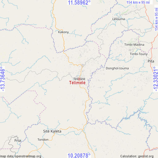
Télimélé GPS coordinates[2]
10° 54' 0" North, 13° 1' 59.988" West
| Map corner | latitude | longitude |
|---|---|---|
| Upper-left | 11.58962°, | -13.73646° |
| Center: | 10.9°, | -13.03333° |
| Lower-right: | 10.20878°, | -12.33021° |
| Map W x H: | 153.5×153.5 km | = 95.4×95.4mi |
| max Lat: | 12.5311° ⇑30.8% North |
| Télimélé: | 10.9° |
| min Lat: | ⇓69.2% South 7.56748° |
| min Long | Télimélé | max Long |
| -14.36667° | -13.03333° | -8.53333° |
| W 35.9%⇐ | ⇒64.1% E |
Elevation
Elevation of Télimélé is 610 m = 2001 ft, and this is 176.6 m = 579 ft above average elevation for this country.
| Max E: |
1440 m = 4724 ft | 23.1% |
| Télimélé | 610 m 2001 ft | |
| Avg. | 433.4 m = 1422 ft | |
Min E: |
0 m = 0 ft | 76.9% |
See also: Guinea elevation on elevation.city.
Geographical zone
Télimélé is located in North Torrid zone (between Equator and Tropic of Cancer). Distance of Equator is 1212 km =753.1 mi to South.| Distance of | km | miles | from Télimélé |
|---|---|---|---|
| North Pole | 8795.1 | 5465 | to North |
| Arctic Circle | 6189.2 | 3845.8 | to North |
| Tropic Cancer | 1394 | 866.2 | to North |
| Equator | 1212 | 753.1 | to South |


Nearby cities:
15 places around Télimélé: (largest is in red/bold)
• Boffa
136.4 km =84.8 mi,  233°
233°
• Boké
137.3 km =85.3 mi,  271°
271°
• Coyah
138.2 km =85.9 mi,  196°
196°
• Dalaba
88.6 km =55.1 mi,  105°
105°
• Dubréka
134.4 km =83.5 mi, 203°
• Fria
84.4 km =52.4 mi, 225°
• Gaoual
96.2 km =59.8 mi,  349°
349°
• Kimbo
79.2 km =49.2 mi, 225°
• Kindia
95.5 km =59.3 mi,  168°
168°
• Koubia
145.7 km =90.5 mi,  58°
58°
• Labé
94.1 km =58.5 mi, 60°
• Lélouma
69.7 km =43.3 mi,  33°
33°
• Mamou
118.3 km =73.5 mi,  119°
119°
• Pita
71.9 km =44.7 mi,  75°
75°
• Tondon
68.7 km =42.7 mi,  210°
210°
Sources, notices
• [Note1] Compared only with cities in Guinea existing in our database
• [Src1] Map data: © OpenStreetMap contributors (CC-BY-SA)
• [Src2] Other city data from geonames.org with taken over terms of usage.
• [Src3] Geographical zone / Annual Mean Temperature by Robert A. Rohde @ Wikipedia
