Dalaba geodata
Dalaba (Mamou) is a seat of a second-order administrative division; located in Guinea in Africa/Conakry (GMT+0) time zone. With population of 7,036 people, there are 31 cities with bigger population in this country. Compared to other cities in Guinea, 61.5% of cities are located further ↓South; 51.3% of cities are located further ←West and 97.4% of cities have lower elevation than Dalaba. Note1


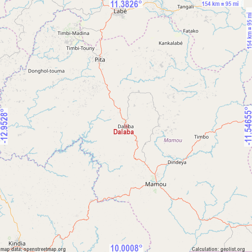
Dalaba GPS coordinates[2]
10° 41' 32.964" North, 12° 14' 58.812" West
| Map corner | latitude | longitude |
|---|---|---|
| Upper-left | 11.3826°, | -12.9528° |
| Center: | 10.69249°, | -12.24967° |
| Lower-right: | 10.0008°, | -11.54655° |
| Map W x H: | 153.6×153.6 km | = 95.4×95.4mi |
| max Lat: | 12.5311° ⇑38.5% North |
| Dalaba: | 10.69249° |
| min Lat: | ⇓61.5% South 7.56748° |
| min Long | Dalaba | max Long |
| -14.36667° | -12.24967° | -8.53333° |
| W 51.3%⇐ | ⇒48.7% E |
Elevation
Elevation of Dalaba is 1240 m = 4068 ft, and this is 806.6 m = 2646 ft above average elevation for this country.
| Max E: |
1440 m = 4724 ft | 2.6% |
| Dalaba | 1240 m 4068 ft | |
| Avg. | 433.4 m = 1422 ft | |
Min E: |
0 m = 0 ft | 97.4% |
See also: Guinea elevation on elevation.city.
Geographical zone
Dalaba is located in North Torrid zone (between Equator and Tropic of Cancer). Distance of Equator is 1188.9 km =738.7 mi to South.| Distance of | km | miles | from Dalaba |
|---|---|---|---|
| North Pole | 8818.2 | 5479.4 | to North |
| Arctic Circle | 6212.3 | 3860.1 | to North |
| Tropic Cancer | 1417 | 880.5 | to North |
| Equator | 1188.9 | 738.7 | to South |


Nearby cities:
15 places around Dalaba: (largest is in red/bold)
• Coyah
165.7 km =103 mi,  228°
228°
• Dabola
124.9 km =77.6 mi,  87°
87°
• Fria
150.1 km =93.3 mi,  256°
256°
• Gaoual
156.7 km =97.4 mi,  318°
318°
• Kimbo
145.8 km =90.6 mi, 257°
• Kindia
97.6 km =60.6 mi,  223°
223°
• Koubia
106.7 km =66.3 mi,  21°
21°
• Labé
69.7 km =43.3 mi,  356°
356°
• Lélouma
94 km =58.4 mi,  329°
329°
• Mali
154.3 km =95.9 mi, 358°
• Mamou
39.3 km =24.4 mi,  153°
153°
• Pita
43.7 km =27.2 mi,  338°
338°
• Tondon
125.6 km =78 mi,  253°
253°
• Tougué
105.3 km =65.4 mi,  37°
37°
• Télimélé
88.6 km =55.1 mi,  285°
285°
Sources, notices
• [Note1] Compared only with cities in Guinea existing in our database
• [Src1] Map data: © OpenStreetMap contributors (CC-BY-SA)
• [Src2] Other city data from geonames.org with taken over terms of usage.
• [Src3] Geographical zone / Annual Mean Temperature by Robert A. Rohde @ Wikipedia
