Conakry geodata
Conakry is a capital of a political entity; located in Guinea in Africa/Conakry (GMT+0) time zone. With population of 1,767,200 people, there is 1 city with bigger population in this country. Compared to other cities in Guinea, 74.4% of cities are located further ↑North; 89.7% of cities are located further →East and 94.9% of cities have higher elevation than Conakry. Note1


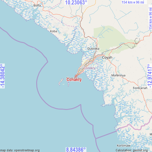
Conakry GPS coordinates[2]
9° 32' 16.62" North, 13° 40' 38.244" West
| Map corner | latitude | longitude |
|---|---|---|
| Upper-left | 10.23063°, | -14.38042° |
| Center: | 9.53795°, | -13.67729° |
| Lower-right: | 8.84386°, | -12.97417° |
| Map W x H: | 154.2×154.2 km | = 95.8×95.8mi |
| max Lat: | 12.5311° ⇑74.4% North |
| Conakry: | 9.53795° |
| min Lat: | ⇓25.6% South 7.56748° |
| min Long | Conakry | max Long |
| -14.36667° | -13.67729° | -8.53333° |
| W 10.3%⇐ | ⇒89.7% E |
Elevation
Elevation of Conakry is 13 m = 43 ft, and this is 420.4 m = 1379 ft below average elevation for this country.
| Max E: |
1440 m = 4724 ft | 94.9% |
| Avg. | 433.4 m = 1422 ft | |
| Conakry | 13 m = 43 ft | |
Min E: |
0 m = 0 ft | 5.1% |
See also: Conakry elevation on elevation.city.
Geographical zone
Conakry is located in North Torrid zone (between Equator and Tropic of Cancer). Distance of Equator is 1060.5 km =659 mi to South.| Distance of | km | miles | from Conakry |
|---|---|---|---|
| North Pole | 8946.5 | 5559.1 | to North |
| Arctic Circle | 6340.7 | 3939.9 | to North |
| Tropic Cancer | 1545.4 | 960.3 | to North |
| Equator | 1060.5 | 659 | to South |


Nearby cities:
15 places around Conakry: (largest is in red/bold)
• Boffa
80.1 km =49.8 mi,  330°
330°
• Boké
168.9 km =104.9 mi,  336°
336°
• Camayenne
1.2 km =0.7 mi,  254°
254°
• Coyah
37.1 km =23.1 mi,  59°
59°
• Dalaba
202.2 km =125.6 mi,  50°
50°
• Dubréka
32.8 km =20.4 mi,  30°
30°
• Forécariah
65.7 km =40.8 mi,  100°
100°
• Fria
92.7 km =57.6 mi,  6°
6°
• Kimbo
96.9 km =60.2 mi, 8°
• Kindia
106 km =65.9 mi, 57°
• Mamou
197.1 km =122.5 mi, 61°
• Pita
219.7 km =136.5 mi,  39°
39°
• Sanguéya
149.6 km =93 mi, 329°
• Tondon
98.9 km =61.5 mi,  21°
21°
• Télimélé
167 km =103.8 mi, 24°
Sources, notices
• [Note1] Compared only with cities in Guinea existing in our database
• [Src1] Map data: © OpenStreetMap contributors (CC-BY-SA)
• [Src2] Other city data from geonames.org with taken over terms of usage.
• [Src3] Geographical zone / Annual Mean Temperature by Robert A. Rohde @ Wikipedia
