Sanguéya geodata
Sanguéya (Boke) is a populated place; located in Guinea in Africa/Conakry (GMT+0) time zone. With population of 6,117 people, there are 33 cities with bigger population in this country. Compared to other cities in Guinea, 64.1% of cities are located further ↓South; 100% of cities are located further →East and 89.7% of cities have higher elevation than Sanguéya. Note1


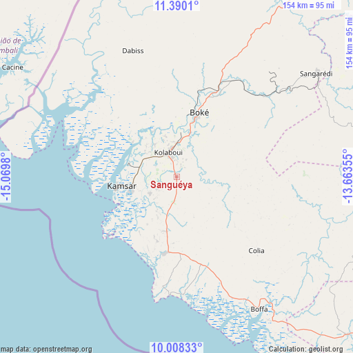
Sanguéya GPS coordinates[2]
10° 42' 0" North, 14° 22' 0.012" West
| Map corner | latitude | longitude |
|---|---|---|
| Upper-left | 11.3901°, | -15.0698° |
| Center: | 10.7°, | -14.36667° |
| Lower-right: | 10.00833°, | -13.66355° |
| Map W x H: | 153.6×153.6 km | = 95.4×95.4mi |
| max Lat: | 12.5311° ⇑35.9% North |
| Sanguéya: | 10.7° |
| min Lat: | ⇓64.1% South 7.56748° |
| min Long | Sanguéya | max Long |
| -14.36667° | -14.36667° | -8.53333° |
| W 0%⇐ | ⇒100% E |
Elevation
Elevation of Sanguéya is 18 m = 59 ft, and this is 415.4 m = 1363 ft below average elevation for this country.
| Max E: |
1440 m = 4724 ft | 89.7% |
| Avg. | 433.4 m = 1422 ft | |
| Sanguéya | 18 m = 59 ft | |
Min E: |
0 m = 0 ft | 10.3% |
See also: Guinea elevation on elevation.city.
Geographical zone
Sanguéya is located in North Torrid zone (between Equator and Tropic of Cancer). Distance of Equator is 1189.7 km =739.2 mi to South.| Distance of | km | miles | from Sanguéya |
|---|---|---|---|
| North Pole | 8817.3 | 5478.8 | to North |
| Arctic Circle | 6211.4 | 3859.6 | to North |
| Tropic Cancer | 1416.2 | 880 | to North |
| Equator | 1189.7 | 739.2 | to South |


Nearby cities:
15 places around Sanguéya: (largest is in red/bold)
• Boffa
69.6 km =43.2 mi,  148°
148°
• Boké
27.1 km =16.8 mi,  17°
17°
• Camayenne
149.3 km =92.8 mi, 150°
• Conakry
149.6 km =93 mi, 149°
• Coyah
154.1 km =95.8 mi,  135°
135°
• Dubréka
136.8 km =85 mi, 137°
• Forécariah
198.8 km =123.5 mi, 135°
• Fria
93.4 km =58 mi,  113°
113°
• Gaoual
172.7 km =107.3 mi,  47°
47°
• Kimbo
95.3 km =59.2 mi, 110°
• Kindia
179.1 km =111.3 mi, 113°
• Lélouma
200.7 km =124.7 mi,  66°
66°
• Pita
219 km =136.1 mi,  79°
79°
• Tondon
117.2 km =72.8 mi, 108°
• Télimélé
147.3 km =91.5 mi, 81°
Sources, notices
• [Note1] Compared only with cities in Guinea existing in our database
• [Src1] Map data: © OpenStreetMap contributors (CC-BY-SA)
• [Src2] Other city data from geonames.org with taken over terms of usage.
• [Src3] Geographical zone / Annual Mean Temperature by Robert A. Rohde @ Wikipedia
