Tokonou geodata
Tokonou (Kankan) is a populated place; located in Guinea in Africa/Conakry (GMT+0) time zone. With population of 6,729 people, there are 32 cities with bigger population in this country. Compared to other cities in Guinea, 71.8% of cities are located further ↑North; 76.9% of cities are located further ←West and 74.4% of cities have lower elevation than Tokonou. Note1


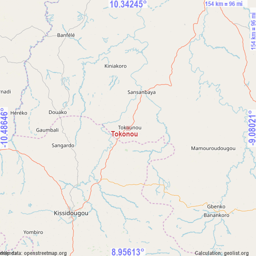
Tokonou GPS coordinates[2]
9° 39' 0" North, 9° 46' 59.988" West
| Map corner | latitude | longitude |
|---|---|---|
| Upper-left | 10.34245°, | -10.48646° |
| Center: | 9.65°, | -9.78333° |
| Lower-right: | 8.95613°, | -9.08021° |
| Map W x H: | 154.1×154.1 km | = 95.8×95.8mi |
| max Lat: | 12.5311° ⇑71.8% North |
| Tokonou: | 9.65° |
| min Lat: | ⇓28.2% South 7.56748° |
| min Long | Tokonou | max Long |
| -14.36667° | -9.78333° | -8.53333° |
| W 76.9%⇐ | ⇒23.1% E |
Elevation
Elevation of Tokonou is 562 m = 1844 ft, and this is 128.6 m = 422 ft above average elevation for this country.
| Max E: |
1440 m = 4724 ft | 25.6% |
| Tokonou | 562 m 1844 ft | |
| Avg. | 433.4 m = 1422 ft | |
Min E: |
0 m = 0 ft | 74.4% |
See also: Guinea elevation on elevation.city.
Geographical zone
Tokonou is located in North Torrid zone (between Equator and Tropic of Cancer). Distance of Equator is 1073 km =666.7 mi to South.| Distance of | km | miles | from Tokonou |
|---|---|---|---|
| North Pole | 8934.1 | 5551.4 | to North |
| Arctic Circle | 6328.2 | 3932.2 | to North |
| Tropic Cancer | 1532.9 | 952.5 | to North |
| Equator | 1073 | 666.7 | to South |


Nearby cities:
15 places around Tokonou: (largest is in red/bold)
• Beyla
164 km =101.9 mi,  130°
130°
• Dabola
189.2 km =117.6 mi,  309°
309°
• Dinguiraye
208.8 km =129.7 mi,  330°
330°
• Faranah
113.8 km =70.7 mi,  292°
292°
• Gueckedou
126.4 km =78.5 mi,  197°
197°
• Kankan
97.1 km =60.3 mi,  32°
32°
• Kissidougou
62.3 km =38.7 mi,  213°
213°
• Kouroussa
111.7 km =69.4 mi,  354°
354°
• Kérouané
94.3 km =58.6 mi,  116°
116°
• Lola
247.4 km =153.7 mi,  146°
146°
• Macenta
127.7 km =79.3 mi,  164°
164°
• Mandiana
161.2 km =100.2 mi,  47°
47°
• Nzérékoré
235.8 km =146.5 mi, 153°
• Siguiri
208.3 km =129.4 mi,  18°
18°
• Yomou
238.5 km =148.2 mi,  166°
166°
Sources, notices
• [Note1] Compared only with cities in Guinea existing in our database
• [Src1] Map data: © OpenStreetMap contributors (CC-BY-SA)
• [Src2] Other city data from geonames.org with taken over terms of usage.
• [Src3] Geographical zone / Annual Mean Temperature by Robert A. Rohde @ Wikipedia
