Nzérékoré geodata
Nzérékoré (Nzerekore) is a seat of a first-order administrative division; located in Guinea in Africa/Conakry (GMT+0) time zone. With population of 132,728 people, there are 2 cities with bigger population in this country. Compared to other cities in Guinea, 97.4% of cities are located further ↑North; 92.3% of cities are located further ←West and 64.1% of cities have lower elevation than Nzérékoré. Note1


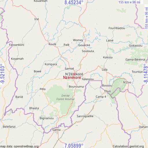
Nzérékoré GPS coordinates[2]
7° 45' 22.464" North, 8° 49' 4.44" West
| Map corner | latitude | longitude |
|---|---|---|
| Upper-left | 8.45234°, | -9.52103° |
| Center: | 7.75624°, | -8.8179° |
| Lower-right: | 7.05899°, | -8.11478° |
| Map W x H: | 154.9×154.9 km | = 96.3×96.3mi |
| max Lat: | 12.5311° ⇑97.4% North |
| Nzérékoré: | 7.75624° |
| min Lat: | ⇓2.6% South 7.56748° |
| min Long | Nzérékoré | max Long |
| -14.36667° | -8.8179° | -8.53333° |
| W 92.3%⇐ | ⇒7.7% E |
Elevation
Elevation of Nzérékoré is 482 m = 1581 ft, and this is 48.6 m = 159 ft above average elevation for this country.
| Max E: |
1440 m = 4724 ft | 35.9% |
| Nzérékoré | 482 m 1581 ft | |
| Avg. | 433.4 m = 1422 ft | |
Min E: |
0 m = 0 ft | 64.1% |
See also: Nzérékoré elevation on elevation.city.
Geographical zone
Nzérékoré is located in North Torrid zone (between Equator and Tropic of Cancer). Distance of Equator is 862.4 km =535.9 mi to South.| Distance of | km | miles | from Nzérékoré |
|---|---|---|---|
| North Pole | 9144.6 | 5682.2 | to North |
| Arctic Circle | 6538.8 | 4063 | to North |
| Tropic Cancer | 1743.5 | 1083.4 | to North |
| Equator | 862.4 | 535.9 | to South |


Nearby cities:
14 places around Nzérékoré: (largest is in red/bold)
• Beyla
105.5 km =65.6 mi,  10°
10°
• Dabola
416.5 km =258.8 mi,  322°
322°
• Faranah
330.5 km =205.4 mi, 320°
• Gueckedou
170.6 km =106 mi,  301°
301°
• Kankan
297.2 km =184.7 mi,  349°
349°
• Kissidougou
212.4 km =132 mi, 318°
• Kouroussa
342.3 km =212.7 mi,  340°
340°
• Kérouané
169.4 km =105.3 mi, 352°
• Lola
31.7 km =19.7 mi,  81°
81°
• Macenta
113.3 km =70.4 mi, 320°
• Mandiana
319.4 km =198.5 mi,  2°
2°
• Siguiri
409.5 km =254.5 mi, 354°
• Tokonou
235.8 km =146.5 mi,  333°
333°
• Yomou
53.3 km =33.1 mi,  246°
246°
Sources, notices
• [Note1] Compared only with cities in Guinea existing in our database
• [Src1] Map data: © OpenStreetMap contributors (CC-BY-SA)
• [Src2] Other city data from geonames.org with taken over terms of usage.
• [Src3] Geographical zone / Annual Mean Temperature by Robert A. Rohde @ Wikipedia
