Mandiana geodata
Mandiana (Kankan) is a seat of a second-order administrative division; located in Guinea in Africa/Conakry (GMT+0) time zone. With population of 10,609 people, there are 23 cities with bigger population in this country. Compared to other cities in Guinea, 56.4% of cities are located further ↓South; 94.9% of cities are located further ←West and 61.5% of cities have higher elevation than Mandiana. Note1


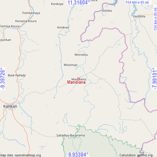
Mandiana GPS coordinates[2]
10° 37' 32.772" North, 8° 41' 38.868" West
| Map corner | latitude | longitude |
|---|---|---|
| Upper-left | 11.31604°, | -9.39726° |
| Center: | 10.62577°, | -8.69413° |
| Lower-right: | 9.93394°, | -7.99101° |
| Map W x H: | 153.7×153.7 km | = 95.5×95.5mi |
| max Lat: | 12.5311° ⇑43.6% North |
| Mandiana: | 10.62577° |
| min Lat: | ⇓56.4% South 7.56748° |
| min Long | Mandiana | max Long |
| -14.36667° | -8.69413° | -8.53333° |
| W 94.9%⇐ | ⇒5.1% E |
Elevation
Elevation of Mandiana is 373 m = 1224 ft, and this is 60.4 m = 198 ft below average elevation for this country.
| Max E: |
1440 m = 4724 ft | 61.5% |
| Avg. | 433.4 m = 1422 ft | |
| Mandiana | 373 m = 1224 ft | |
Min E: |
0 m = 0 ft | 38.5% |
See also: Guinea elevation on elevation.city.
Geographical zone
Mandiana is located in North Torrid zone (between Equator and Tropic of Cancer). Distance of Equator is 1181.5 km =734.1 mi to South.| Distance of | km | miles | from Mandiana |
|---|---|---|---|
| North Pole | 8825.6 | 5484 | to North |
| Arctic Circle | 6219.7 | 3864.7 | to North |
| Tropic Cancer | 1424.4 | 885.1 | to North |
| Equator | 1181.5 | 734.1 | to South |


Nearby cities:
15 places around Mandiana: (largest is in red/bold)
• Beyla
215.3 km =133.8 mi,  178°
178°
• Dabola
264 km =164 mi,  272°
272°
• Dinguiraye
232.4 km =144.4 mi,  288°
288°
• Faranah
233.4 km =145 mi,  253°
253°
• Gueckedou
278 km =172.7 mi,  214°
214°
• Kankan
72 km =44.7 mi, 248°
• Kissidougou
222.2 km =138.1 mi,  223°
223°
• Kouroussa
130 km =80.8 mi, 271°
• Kérouané
155.2 km =96.4 mi,  193°
193°
• Lola
314.7 km =195.5 mi, 176°
• Macenta
246.7 km =153.3 mi,  200°
200°
• Nzérékoré
319.4 km =198.5 mi, 182°
• Siguiri
102.6 km =63.8 mi,  329°
329°
• Tokonou
161.2 km =100.2 mi,  227°
227°
• Tougué
336.7 km =209.2 mi, 285°
Sources, notices
• [Note1] Compared only with cities in Guinea existing in our database
• [Src1] Map data: © OpenStreetMap contributors (CC-BY-SA)
• [Src2] Other city data from geonames.org with taken over terms of usage.
• [Src3] Geographical zone / Annual Mean Temperature by Robert A. Rohde @ Wikipedia
