Yomou geodata
Yomou (Nzerekore) is a seat of a second-order administrative division; located in Guinea in Africa/Conakry (GMT+0) time zone. With population of 3,614 people, there are 37 cities with bigger population in this country. Compared to other cities in Guinea, 100% of cities are located further ↑North; 84.6% of cities are located further ←West and 53.8% of cities have higher elevation than Yomou. Note1


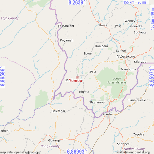
Yomou GPS coordinates[2]
7° 34' 2.928" North, 9° 15' 46.188" West
| Map corner | latitude | longitude |
|---|---|---|
| Upper-left | 8.2639°, | -9.96596° |
| Center: | 7.56748°, | -9.26283° |
| Lower-right: | 6.86993°, | -8.55971° |
| Map W x H: | 155×155 km | = 96.3×96.3mi |
| max Lat: | 12.5311° ⇑100% North |
| Yomou: | 7.56748° |
| min Lat: | ⇓0% South 7.56748° |
| min Long | Yomou | max Long |
| -14.36667° | -9.26283° | -8.53333° |
| W 84.6%⇐ | ⇒15.4% E |
Elevation
Elevation of Yomou is 395 m = 1296 ft, and this is 38.4 m = 126 ft below average elevation for this country.
| Max E: |
1440 m = 4724 ft | 53.8% |
| Avg. | 433.4 m = 1422 ft | |
| Yomou | 395 m = 1296 ft | |
Min E: |
0 m = 0 ft | 46.2% |
See also: Guinea elevation on elevation.city.
Geographical zone
Yomou is located in North Torrid zone (between Equator and Tropic of Cancer). Distance of Equator is 841.4 km =522.8 mi to South.| Distance of | km | miles | from Yomou |
|---|---|---|---|
| North Pole | 9165.6 | 5695.2 | to North |
| Arctic Circle | 6559.7 | 4076 | to North |
| Tropic Cancer | 1764.5 | 1096.4 | to North |
| Equator | 841.4 | 522.8 | to South |


Nearby cities:
15 places around Yomou: (largest is in red/bold)
• Beyla
142 km =88.2 mi,  28°
28°
• Dabola
407.1 km =253 mi,  330°
330°
• Faranah
319.5 km =198.5 mi, 329°
• Gueckedou
146.8 km =91.2 mi,  319°
319°
• Kankan
313.4 km =194.7 mi,  359°
359°
• Kissidougou
202 km =125.5 mi, 332°
• Kouroussa
349.4 km =217.1 mi,  348°
348°
• Kérouané
190.9 km =118.6 mi,  8°
8°
• Lola
84.4 km =52.4 mi,  72°
72°
• Macenta
110.9 km =68.9 mi, 348°
• Mamou
440.4 km =273.7 mi, 315°
• Mandiana
345.7 km =214.8 mi, 10°
• Nzérékoré
53.3 km =33.1 mi, 66°
• Siguiri
428.8 km =266.4 mi,  1°
1°
• Tokonou
238.5 km =148.2 mi, 346°
Sources, notices
• [Note1] Compared only with cities in Guinea existing in our database
• [Src1] Map data: © OpenStreetMap contributors (CC-BY-SA)
• [Src2] Other city data from geonames.org with taken over terms of usage.
• [Src3] Geographical zone / Annual Mean Temperature by Robert A. Rohde @ Wikipedia
