Lola geodata
Lola (Nzerekore) is a seat of a second-order administrative division; located in Guinea in Africa/Conakry (GMT+0) time zone. With population of 1,982 people, there are 39 cities with bigger population in this country. Compared to other cities in Guinea, 94.9% of cities are located further ↑North; 100% of cities are located further ←West and 61.5% of cities have lower elevation than Lola. Note1


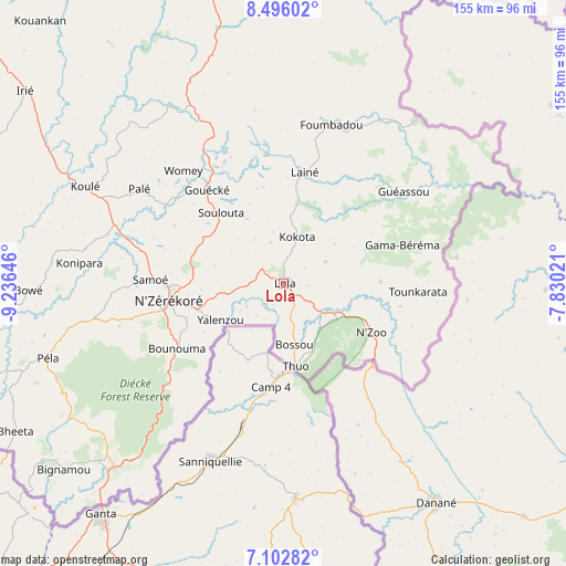
Lola GPS coordinates[2]
7° 48' 0" North, 8° 31' 59.988" West
| Map corner | latitude | longitude |
|---|---|---|
| Upper-left | 8.49602°, | -9.23646° |
| Center: | 7.8°, | -8.53333° |
| Lower-right: | 7.10282°, | -7.83021° |
| Map W x H: | 154.9×154.9 km | = 96.3×96.3mi |
| max Lat: | 12.5311° ⇑94.9% North |
| Lola: | 7.8° |
| min Lat: | ⇓5.1% South 7.56748° |
| min Long | Lola | max Long |
| -14.36667° | -8.53333° | -8.53333° |
| W 100%⇐ | ⇒0% E |
Elevation
Elevation of Lola is 468 m = 1535 ft, and this is 34.6 m = 114 ft above average elevation for this country.
| Max E: |
1440 m = 4724 ft | 38.5% |
| Lola | 468 m 1535 ft | |
| Avg. | 433.4 m = 1422 ft | |
Min E: |
0 m = 0 ft | 61.5% |
See also: Guinea elevation on elevation.city.
Geographical zone
Lola is located in North Torrid zone (between Equator and Tropic of Cancer). Distance of Equator is 867.3 km =538.9 mi to South.| Distance of | km | miles | from Lola |
|---|---|---|---|
| North Pole | 9139.8 | 5679.2 | to North |
| Arctic Circle | 6533.9 | 4060 | to North |
| Tropic Cancer | 1738.6 | 1080.3 | to North |
| Equator | 867.3 | 538.9 | to South |


Nearby cities:
14 places around Lola: (largest is in red/bold)
• Beyla
99.8 km =62 mi,  352°
352°
• Dabola
432.3 km =268.6 mi,  319°
319°
• Faranah
347.8 km =216.1 mi, 315°
• Gueckedou
195.7 km =121.6 mi,  295°
295°
• Kankan
299.7 km =186.2 mi,  343°
343°
• Kissidougou
231.1 km =143.6 mi,  311°
311°
• Kouroussa
349.8 km =217.4 mi,  334°
334°
• Kérouané
171.5 km =106.6 mi, 341°
• Macenta
132.2 km =82.1 mi, 308°
• Mandiana
314.7 km =195.5 mi,  356°
356°
• Nzérékoré
31.7 km =19.7 mi,  261°
261°
• Siguiri
408.8 km =254 mi, 350°
• Tokonou
247.4 km =153.7 mi, 326°
• Yomou
84.4 km =52.4 mi,  252°
252°
Sources, notices
• [Note1] Compared only with cities in Guinea existing in our database
• [Src1] Map data: © OpenStreetMap contributors (CC-BY-SA)
• [Src2] Other city data from geonames.org with taken over terms of usage.
• [Src3] Geographical zone / Annual Mean Temperature by Robert A. Rohde @ Wikipedia
