Kankan geodata
Kankan is a seat of a first-order administrative division; located in Guinea in Africa/Conakry (GMT+0) time zone. With population of 114,009 people, there are 4 cities with bigger population in this country. Compared to other cities in Guinea, 51.3% of cities are located further ↓South; 82.1% of cities are located further ←West and 59% of cities have higher elevation than Kankan. Note1


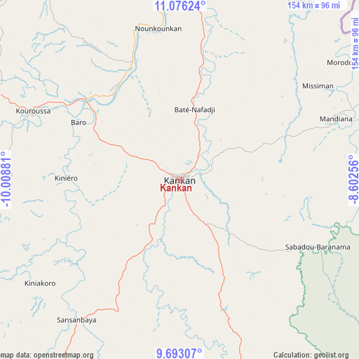
Kankan GPS coordinates[2]
10° 23' 7.512" North, 9° 18' 20.448" West
| Map corner | latitude | longitude |
|---|---|---|
| Upper-left | 11.07624°, | -10.00881° |
| Center: | 10.38542°, | -9.30568° |
| Lower-right: | 9.69307°, | -8.60256° |
| Map W x H: | 153.8×153.8 km | = 95.6×95.6mi |
| max Lat: | 12.5311° ⇑48.7% North |
| Kankan: | 10.38542° |
| min Lat: | ⇓51.3% South 7.56748° |
| min Long | Kankan | max Long |
| -14.36667° | -9.30568° | -8.53333° |
| W 82.1%⇐ | ⇒17.9% E |
Elevation
Elevation of Kankan is 381 m = 1250 ft, and this is 52.4 m = 172 ft below average elevation for this country.
| Max E: |
1440 m = 4724 ft | 59% |
| Avg. | 433.4 m = 1422 ft | |
| Kankan | 381 m = 1250 ft | |
Min E: |
0 m = 0 ft | 41% |
See also: Kankan elevation on elevation.city.
Geographical zone
Kankan is located in North Torrid zone (between Equator and Tropic of Cancer). Distance of Equator is 1154.8 km =717.6 mi to South.| Distance of | km | miles | from Kankan |
|---|---|---|---|
| North Pole | 8852.3 | 5500.6 | to North |
| Arctic Circle | 6246.4 | 3881.3 | to North |
| Tropic Cancer | 1451.2 | 901.7 | to North |
| Equator | 1154.8 | 717.6 | to South |


Nearby cities:
15 places around Kankan: (largest is in red/bold)
• Beyla
201.8 km =125.4 mi,  159°
159°
• Dabola
201 km =124.9 mi,  281°
281°
• Dinguiraye
183.6 km =114.1 mi,  303°
303°
• Faranah
161.9 km =100.6 mi,  256°
256°
• Gueckedou
221.6 km =137.7 mi,  204°
204°
• Kissidougou
159.4 km =99 mi,  213°
213°
• Kouroussa
69.7 km =43.3 mi,  294°
294°
• Kérouané
128.4 km =79.8 mi,  165°
165°
• Lola
299.7 km =186.2 mi, 163°
• Macenta
205.6 km =127.8 mi,  185°
185°
• Mandiana
72 km =44.7 mi,  68°
68°
• Nzérékoré
297.2 km =184.7 mi, 169°
• Siguiri
116.3 km =72.3 mi,  7°
7°
• Tokonou
97.1 km =60.3 mi, 212°
• Tougué
283.2 km =176 mi, 294°
Sources, notices
• [Note1] Compared only with cities in Guinea existing in our database
• [Src1] Map data: © OpenStreetMap contributors (CC-BY-SA)
• [Src2] Other city data from geonames.org with taken over terms of usage.
• [Src3] Geographical zone / Annual Mean Temperature by Robert A. Rohde @ Wikipedia
