Gueckedou geodata
Gueckedou (Nzerekore) is a seat of a second-order administrative division; located in Guinea in Africa/Conakry (GMT+0) time zone. With population of 79,140 people, there are 5 cities with bigger population in this country. Compared to other cities in Guinea, 89.7% of cities are located further ↑North; 69.2% of cities are located further ←West and 51.3% of cities have lower elevation than Gueckedou. Note1


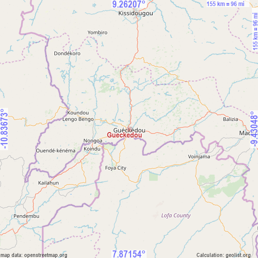
Gueckedou GPS coordinates[2]
8° 34' 2.784" North, 10° 8' 0.96" West
| Map corner | latitude | longitude |
|---|---|---|
| Upper-left | 9.26207°, | -10.83673° |
| Center: | 8.56744°, | -10.1336° |
| Lower-right: | 7.87154°, | -9.43048° |
| Map W x H: | 154.6×154.6 km | = 96.1×96.1mi |
| max Lat: | 12.5311° ⇑89.7% North |
| Gueckedou: | 8.56744° |
| min Lat: | ⇓10.3% South 7.56748° |
| min Long | Gueckedou | max Long |
| -14.36667° | -10.1336° | -8.53333° |
| W 69.2%⇐ | ⇒30.8% E |
Elevation
Elevation of Gueckedou is 430 m = 1411 ft, and this is 3.4 m = 11 ft below average elevation for this country.
| Max E: |
1440 m = 4724 ft | 48.7% |
| Avg. | 433.4 m = 1422 ft | |
| Gueckedou | 430 m = 1411 ft | |
Min E: |
0 m = 0 ft | 51.3% |
See also: Gueckedou elevation on elevation.city.
Geographical zone
Gueckedou is located in North Torrid zone (between Equator and Tropic of Cancer). Distance of Equator is 952.6 km =591.9 mi to South.| Distance of | km | miles | from Gueckedou |
|---|---|---|---|
| North Pole | 9054.5 | 5626.2 | to North |
| Arctic Circle | 6448.6 | 4007 | to North |
| Tropic Cancer | 1653.3 | 1027.3 | to North |
| Equator | 952.6 | 591.9 | to South |


Nearby cities:
15 places around Gueckedou: (largest is in red/bold)
• Beyla
163.8 km =101.8 mi,  85°
85°
• Dabola
264.4 km =164.3 mi,  336°
336°
• Dinguiraye
309.3 km =192.2 mi,  348°
348°
• Faranah
176.9 km =109.9 mi, 337°
• Kankan
221.6 km =137.7 mi,  24°
24°
• Kissidougou
68.7 km =42.7 mi,  3°
3°
• Kouroussa
233.2 km =144.9 mi,  6°
6°
• Kérouané
145.2 km =90.2 mi,  57°
57°
• Lola
195.7 km =121.6 mi,  115°
115°
• Macenta
72.9 km =45.3 mi, 92°
• Mamou
294.1 km =182.7 mi,  313°
313°
• Mandiana
278 km =172.7 mi,  34°
34°
• Nzérékoré
170.6 km =106 mi, 121°
• Tokonou
126.4 km =78.5 mi, 17°
• Yomou
146.8 km =91.2 mi,  139°
139°
Sources, notices
• [Note1] Compared only with cities in Guinea existing in our database
• [Src1] Map data: © OpenStreetMap contributors (CC-BY-SA)
• [Src2] Other city data from geonames.org with taken over terms of usage.
• [Src3] Geographical zone / Annual Mean Temperature by Robert A. Rohde @ Wikipedia
