Dabola geodata
Dabola (Faranah) is a seat of a second-order administrative division; located in Guinea in Africa/Conakry (GMT+0) time zone. With population of 13,057 people, there are 19 cities with bigger population in this country. Compared to other cities in Guinea, 66.7% of cities are located further ↓South; 61.5% of cities are located further ←West and 59% of cities have lower elevation than Dabola. Note1


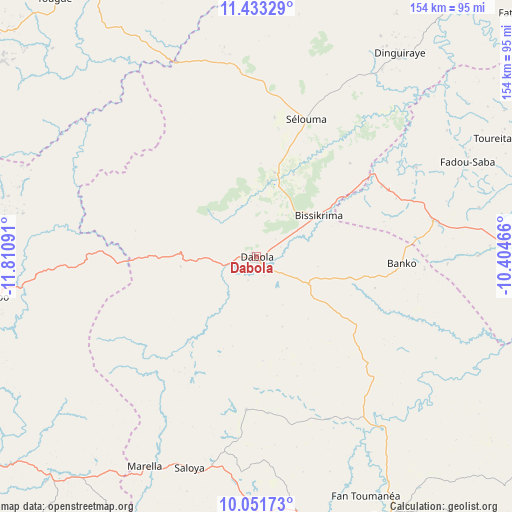
Dabola GPS coordinates[2]
10° 44' 35.88" North, 11° 6' 28.008" West
| Map corner | latitude | longitude |
|---|---|---|
| Upper-left | 11.43329°, | -11.81091° |
| Center: | 10.7433°, | -11.10778° |
| Lower-right: | 10.05173°, | -10.40466° |
| Map W x H: | 153.6×153.6 km | = 95.4×95.4mi |
| max Lat: | 12.5311° ⇑33.3% North |
| Dabola: | 10.7433° |
| min Lat: | ⇓66.7% South 7.56748° |
| min Long | Dabola | max Long |
| -14.36667° | -11.10778° | -8.53333° |
| W 61.5%⇐ | ⇒38.5% E |
Elevation
Elevation of Dabola is 434 m = 1424 ft, and this is 0.60000000000002 m = 2 ft above average elevation for this country.
| Max E: |
1440 m = 4724 ft | 41% |
| Dabola | 434 m 1424 ft | |
| Avg. | 433.4 m = 1422 ft | |
Min E: |
0 m = 0 ft | 59% |
See also: Guinea elevation on elevation.city.
Geographical zone
Dabola is located in North Torrid zone (between Equator and Tropic of Cancer). Distance of Equator is 1194.5 km =742.2 mi to South.| Distance of | km | miles | from Dabola |
|---|---|---|---|
| North Pole | 8812.5 | 5475.8 | to North |
| Arctic Circle | 6206.6 | 3856.6 | to North |
| Tropic Cancer | 1411.4 | 877 | to North |
| Equator | 1194.5 | 742.2 | to South |


Nearby cities:
15 places around Dabola: (largest is in red/bold)
• Dalaba
124.9 km =77.6 mi,  267°
267°
• Dinguiraye
74.6 km =46.4 mi,  35°
35°
• Faranah
87.7 km =54.5 mi,  152°
152°
• Kankan
201 km =124.9 mi,  101°
101°
• Kindia
206.9 km =128.6 mi,  248°
248°
• Kissidougou
205.5 km =127.7 mi, 147°
• Koubia
127.1 km =79 mi,  317°
317°
• Kouroussa
134.2 km =83.4 mi,  94°
94°
• Labé
143.3 km =89 mi,  296°
296°
• Lélouma
187.7 km =116.6 mi,  293°
293°
• Mali
197.2 km =122.5 mi, 318°
• Mamou
115 km =71.5 mi, 249°
• Pita
144.9 km =90 mi,  284°
284°
• Tokonou
189.2 km =117.6 mi,  129°
129°
• Tougué
98.9 km =61.5 mi, 322°
Sources, notices
• [Note1] Compared only with cities in Guinea existing in our database
• [Src1] Map data: © OpenStreetMap contributors (CC-BY-SA)
• [Src2] Other city data from geonames.org with taken over terms of usage.
• [Src3] Geographical zone / Annual Mean Temperature by Robert A. Rohde @ Wikipedia
