Kouroussa geodata
Kouroussa (Kankan) is a seat of a second-order administrative division; located in Guinea in Africa/Conakry (GMT+0) time zone. With population of 14,223 people, there are 17 cities with bigger population in this country. Compared to other cities in Guinea, 59% of cities are located further ↓South; 74.4% of cities are located further ←West and 56.4% of cities have higher elevation than Kouroussa. Note1


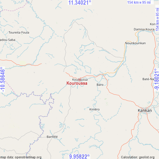
Kouroussa GPS coordinates[2]
10° 39' 0" North, 9° 52' 59.988" West
| Map corner | latitude | longitude |
|---|---|---|
| Upper-left | 11.34021°, | -10.58646° |
| Center: | 10.65°, | -9.88333° |
| Lower-right: | 9.95822°, | -9.18021° |
| Map W x H: | 153.7×153.7 km | = 95.5×95.5mi |
| max Lat: | 12.5311° ⇑41% North |
| Kouroussa: | 10.65° |
| min Lat: | ⇓59% South 7.56748° |
| min Long | Kouroussa | max Long |
| -14.36667° | -9.88333° | -8.53333° |
| W 74.4%⇐ | ⇒25.6% E |
Elevation
Elevation of Kouroussa is 383 m = 1257 ft, and this is 50.4 m = 165 ft below average elevation for this country.
| Max E: |
1440 m = 4724 ft | 56.4% |
| Avg. | 433.4 m = 1422 ft | |
| Kouroussa | 383 m = 1257 ft | |
Min E: |
0 m = 0 ft | 43.6% |
See also: Guinea elevation on elevation.city.
Geographical zone
Kouroussa is located in North Torrid zone (between Equator and Tropic of Cancer). Distance of Equator is 1184.2 km =735.8 mi to South.| Distance of | km | miles | from Kouroussa |
|---|---|---|---|
| North Pole | 8822.9 | 5482.3 | to North |
| Arctic Circle | 6217 | 3863.1 | to North |
| Tropic Cancer | 1421.7 | 883.4 | to North |
| Equator | 1184.2 | 735.8 | to South |


Nearby cities:
15 places around Kouroussa: (largest is in red/bold)
• Beyla
256.5 km =159.4 mi,  148°
148°
• Dabola
134.2 km =83.4 mi,  274°
274°
• Dinguiraye
115.1 km =71.5 mi,  308°
308°
• Faranah
116 km =72.1 mi,  234°
234°
• Gueckedou
233.2 km =144.9 mi,  186°
186°
• Kankan
69.7 km =43.3 mi,  114°
114°
• Kissidougou
164.6 km =102.3 mi, 188°
• Koubia
242.9 km =150.9 mi,  295°
295°
• Kérouané
180.7 km =112.3 mi, 148°
• Macenta
238.5 km =148.2 mi,  169°
169°
• Mamou
243.3 km =151.2 mi,  262°
262°
• Mandiana
130 km =80.8 mi,  91°
91°
• Siguiri
116.1 km =72.1 mi,  42°
42°
• Tokonou
111.7 km =69.4 mi, 174°
• Tougué
213.5 km =132.7 mi,  294°
294°
Sources, notices
• [Note1] Compared only with cities in Guinea existing in our database
• [Src1] Map data: © OpenStreetMap contributors (CC-BY-SA)
• [Src2] Other city data from geonames.org with taken over terms of usage.
• [Src3] Geographical zone / Annual Mean Temperature by Robert A. Rohde @ Wikipedia
