Lélouma geodata
Lélouma (Labe) is a seat of a second-order administrative division; located in Guinea in Africa/Conakry (GMT+0) time zone. With population of 4,777 people, there are 36 cities with bigger population in this country. Compared to other cities in Guinea, 84.6% of cities are located further ↓South; 59% of cities are located further →East and 89.7% of cities have lower elevation than Lélouma. Note1


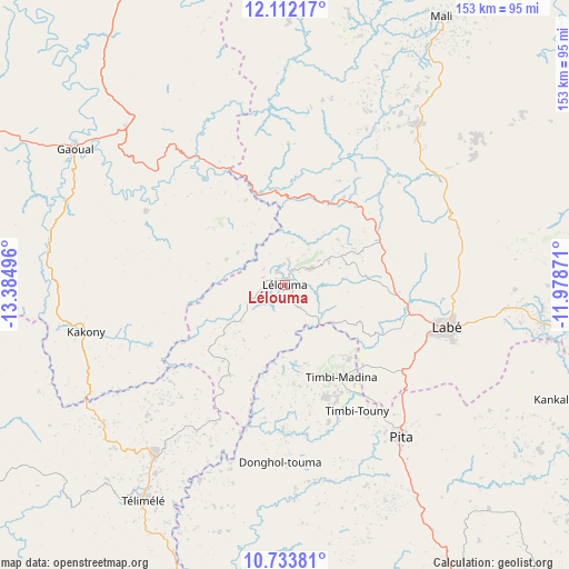
Lélouma GPS coordinates[2]
11° 25' 25.788" North, 12° 40' 54.588" West
| Map corner | latitude | longitude |
|---|---|---|
| Upper-left | 12.11217°, | -13.38496° |
| Center: | 11.42383°, | -12.68183° |
| Lower-right: | 10.73381°, | -11.97871° |
| Map W x H: | 153.3×153.3 km | = 95.3×95.3mi |
| max Lat: | 12.5311° ⇑15.4% North |
| Lélouma: | 11.42383° |
| min Lat: | ⇓84.6% South 7.56748° |
| min Long | Lélouma | max Long |
| -14.36667° | -12.68183° | -8.53333° |
| W 41%⇐ | ⇒59% E |
Elevation
Elevation of Lélouma is 955 m = 3133 ft, and this is 521.6 m = 1711 ft above average elevation for this country.
| Max E: |
1440 m = 4724 ft | 10.3% |
| Lélouma | 955 m 3133 ft | |
| Avg. | 433.4 m = 1422 ft | |
Min E: |
0 m = 0 ft | 89.7% |
See also: Guinea elevation on elevation.city.
Geographical zone
Lélouma is located in North Torrid zone (between Equator and Tropic of Cancer). Distance of Equator is 1270.2 km =789.3 mi to South.| Distance of | km | miles | from Lélouma |
|---|---|---|---|
| North Pole | 8736.9 | 5428.9 | to North |
| Arctic Circle | 6131 | 3809.6 | to North |
| Tropic Cancer | 1335.7 | 830 | to North |
| Equator | 1270.2 | 789.3 | to South |


Nearby cities:
15 places around Lélouma: (largest is in red/bold)
• Dalaba
94 km =58.4 mi,  149°
149°
• Fria
153.3 km =95.3 mi,  219°
219°
• Gaoual
67.1 km =41.7 mi,  302°
302°
• Kimbo
148.1 km =92 mi, 219°
• Kindia
153.3 km =95.3 mi,  187°
187°
• Koubia
87.6 km =54.4 mi,  78°
78°
• Koundara
135.6 km =84.3 mi,  330°
330°
• Labé
45 km =28 mi,  105°
105°
• Mali
84 km =52.2 mi,  29°
29°
• Mamou
133.2 km =82.8 mi, 151°
• Pita
51.2 km =31.8 mi,  142°
142°
• Tondon
138.3 km =85.9 mi,  211°
211°
• Tougué
110.9 km =68.9 mi,  88°
88°
• Télimélé
69.7 km =43.3 mi, 213°
• Youkounkoun
132.1 km =82.1 mi,  338°
338°
Sources, notices
• [Note1] Compared only with cities in Guinea existing in our database
• [Src1] Map data: © OpenStreetMap contributors (CC-BY-SA)
• [Src2] Other city data from geonames.org with taken over terms of usage.
• [Src3] Geographical zone / Annual Mean Temperature by Robert A. Rohde @ Wikipedia
