Tougué geodata
Tougué (Labe) is a seat of a second-order administrative division; located in Guinea in Africa/Conakry (GMT+0) time zone. With population of 25,531 people, there are 14 cities with bigger population in this country. Compared to other cities in Guinea, 87.2% of cities are located further ↓South; 59% of cities are located further ←West and 87.2% of cities have lower elevation than Tougué. Note1


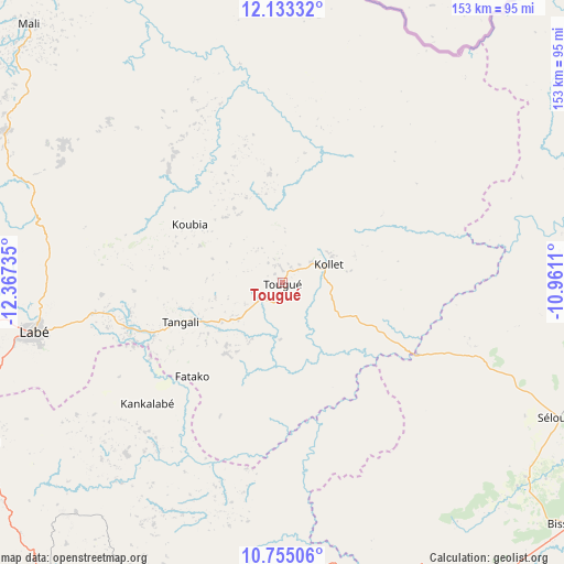
Tougué GPS coordinates[2]
11° 26' 42.108" North, 11° 39' 51.192" West
| Map corner | latitude | longitude |
|---|---|---|
| Upper-left | 12.13332°, | -12.36735° |
| Center: | 11.44503°, | -11.66422° |
| Lower-right: | 10.75506°, | -10.9611° |
| Map W x H: | 153.2×153.3 km | = 95.2×95.3mi |
| max Lat: | 12.5311° ⇑12.8% North |
| Tougué: | 11.44503° |
| min Lat: | ⇓87.2% South 7.56748° |
| min Long | Tougué | max Long |
| -14.36667° | -11.66422° | -8.53333° |
| W 59%⇐ | ⇒41% E |
Elevation
Elevation of Tougué is 805 m = 2641 ft, and this is 371.6 m = 1219 ft above average elevation for this country.
| Max E: |
1440 m = 4724 ft | 12.8% |
| Tougué | 805 m 2641 ft | |
| Avg. | 433.4 m = 1422 ft | |
Min E: |
0 m = 0 ft | 87.2% |
See also: Guinea elevation on elevation.city.
Geographical zone
Tougué is located in North Torrid zone (between Equator and Tropic of Cancer). Distance of Equator is 1272.6 km =790.8 mi to South.| Distance of | km | miles | from Tougué |
|---|---|---|---|
| North Pole | 8734.5 | 5427.4 | to North |
| Arctic Circle | 6128.6 | 3808.1 | to North |
| Tropic Cancer | 1333.4 | 828.5 | to North |
| Equator | 1272.6 | 790.8 | to South |


Nearby cities:
15 places around Tougué: (largest is in red/bold)
• Dabola
98.9 km =61.5 mi,  142°
142°
• Dalaba
105.3 km =65.4 mi,  217°
217°
• Dinguiraye
105.2 km =65.4 mi,  99°
99°
• Faranah
185.8 km =115.5 mi,  147°
147°
• Gaoual
170.7 km =106.1 mi,  281°
281°
• Kindia
202.6 km =125.9 mi, 220°
• Koubia
29.6 km =18.4 mi,  302°
302°
• Koundara
212.1 km =131.8 mi, 302°
• Labé
68.9 km =42.8 mi,  258°
258°
• Lélouma
110.9 km =68.9 mi,  268°
268°
• Mali
98.6 km =61.3 mi,  315°
315°
• Mamou
127.7 km =79.3 mi,  201°
201°
• Pita
90.5 km =56.2 mi,  241°
241°
• Télimélé
161.2 km =100.2 mi,  247°
247°
• Youkounkoun
199.3 km =123.8 mi,  307°
307°
Sources, notices
• [Note1] Compared only with cities in Guinea existing in our database
• [Src1] Map data: © OpenStreetMap contributors (CC-BY-SA)
• [Src2] Other city data from geonames.org with taken over terms of usage.
• [Src3] Geographical zone / Annual Mean Temperature by Robert A. Rohde @ Wikipedia
