Koubia geodata
Koubia (Labe) is a seat of a second-order administrative division; located in Guinea in Africa/Conakry (GMT+0) time zone. With population of 9,909 people, there are 25 cities with bigger population in this country. Compared to other cities in Guinea, 89.7% of cities are located further ↓South; 56.4% of cities are located further ←West and 84.6% of cities have lower elevation than Koubia. Note1


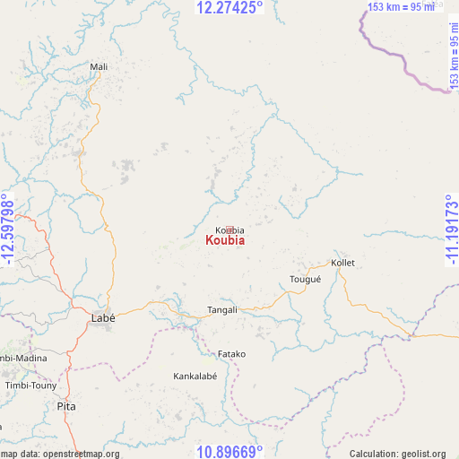
Koubia GPS coordinates[2]
11° 35' 10.752" North, 11° 53' 41.46" West
| Map corner | latitude | longitude |
|---|---|---|
| Upper-left | 12.27425°, | -12.59798° |
| Center: | 11.58632°, | -11.89485° |
| Lower-right: | 10.89669°, | -11.19173° |
| Map W x H: | 153.2×153.2 km | = 95.2×95.2mi |
| max Lat: | 12.5311° ⇑10.3% North |
| Koubia: | 11.58632° |
| min Lat: | ⇓89.7% South 7.56748° |
| min Long | Koubia | max Long |
| -14.36667° | -11.89485° | -8.53333° |
| W 56.4%⇐ | ⇒43.6% E |
Elevation
Elevation of Koubia is 750 m = 2461 ft, and this is 316.6 m = 1039 ft above average elevation for this country.
| Max E: |
1440 m = 4724 ft | 15.4% |
| Koubia | 750 m 2461 ft | |
| Avg. | 433.4 m = 1422 ft | |
Min E: |
0 m = 0 ft | 84.6% |
See also: Guinea elevation on elevation.city.
Geographical zone
Koubia is located in North Torrid zone (between Equator and Tropic of Cancer). Distance of Equator is 1288.3 km =800.5 mi to South.| Distance of | km | miles | from Koubia |
|---|---|---|---|
| North Pole | 8718.8 | 5417.6 | to North |
| Arctic Circle | 6112.9 | 3798.4 | to North |
| Tropic Cancer | 1317.6 | 818.7 | to North |
| Equator | 1288.3 | 800.5 | to South |


Nearby cities:
15 places around Koubia: (largest is in red/bold)
• Dabola
127.1 km =79 mi,  137°
137°
• Dalaba
106.7 km =66.3 mi,  201°
201°
• Dinguiraye
133 km =82.6 mi,  104°
104°
• Gaoual
143.3 km =89 mi,  277°
277°
• Kindia
200.4 km =124.5 mi,  211°
211°
• Koundara
182.5 km =113.4 mi,  303°
303°
• Labé
51.8 km =32.2 mi,  234°
234°
• Lélouma
87.6 km =54.4 mi,  258°
258°
• Mali
70.2 km =43.6 mi,  321°
321°
• Mamou
136.3 km =84.7 mi,  189°
189°
• Pita
80.1 km =49.8 mi,  222°
222°
• Tondon
208.9 km =129.8 mi, 229°
• Tougué
29.6 km =18.4 mi,  122°
122°
• Télimélé
145.7 km =90.5 mi,  238°
238°
• Youkounkoun
169.9 km =105.6 mi,  308°
308°
Sources, notices
• [Note1] Compared only with cities in Guinea existing in our database
• [Src1] Map data: © OpenStreetMap contributors (CC-BY-SA)
• [Src2] Other city data from geonames.org with taken over terms of usage.
• [Src3] Geographical zone / Annual Mean Temperature by Robert A. Rohde @ Wikipedia
