Labé geodata
Labé (Labe) is a seat of a second-order administrative division; located in Guinea in Africa/Conakry (GMT+0) time zone. With population of 58,649 people, there are 7 cities with bigger population in this country. Compared to other cities in Guinea, 79.5% of cities are located further ↓South; 51.3% of cities are located further →East and 94.9% of cities have lower elevation than Labé. Note1


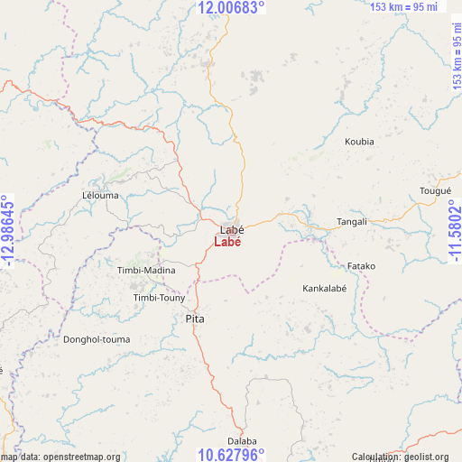
Labé GPS coordinates[2]
11° 19' 5.628" North, 12° 16' 59.952" West
| Map corner | latitude | longitude |
|---|---|---|
| Upper-left | 12.00683°, | -12.98645° |
| Center: | 11.31823°, | -12.28332° |
| Lower-right: | 10.62796°, | -11.5802° |
| Map W x H: | 153.3×153.3 km | = 95.3×95.3mi |
| max Lat: | 12.5311° ⇑20.5% North |
| Labé: | 11.31823° |
| min Lat: | ⇓79.5% South 7.56748° |
| min Long | Labé | max Long |
| -14.36667° | -12.28332° | -8.53333° |
| W 48.7%⇐ | ⇒51.3% E |
Elevation
Elevation of Labé is 1026 m = 3366 ft, and this is 592.6 m = 1944 ft above average elevation for this country.
| Max E: |
1440 m = 4724 ft | 5.1% |
| Labé | 1026 m 3366 ft | |
| Avg. | 433.4 m = 1422 ft | |
Min E: |
0 m = 0 ft | 94.9% |
See also: Labé elevation on elevation.city.
Geographical zone
Labé is located in North Torrid zone (between Equator and Tropic of Cancer). Distance of Equator is 1258.5 km =782 mi to South.| Distance of | km | miles | from Labé |
|---|---|---|---|
| North Pole | 8748.6 | 5436.1 | to North |
| Arctic Circle | 6142.7 | 3816.9 | to North |
| Tropic Cancer | 1347.4 | 837.2 | to North |
| Equator | 1258.5 | 782 | to South |


Nearby cities:
15 places around Labé: (largest is in red/bold)
• Dabola
143.3 km =89 mi,  116°
116°
• Dalaba
69.7 km =43.3 mi,  176°
176°
• Dinguiraye
171.3 km =106.4 mi,  91°
91°
• Gaoual
110.8 km =68.8 mi,  295°
295°
• Kindia
154 km =95.7 mi,  204°
204°
• Koubia
51.8 km =32.2 mi,  54°
54°
• Koundara
170.3 km =105.8 mi,  319°
319°
• Lélouma
45 km =28 mi,  285°
285°
• Mali
84.6 km =52.6 mi,  358°
358°
• Mamou
106.9 km =66.4 mi,  168°
168°
• Pita
31.3 km =19.4 mi, 202°
• Tondon
157.4 km =97.8 mi,  227°
227°
• Tougué
68.9 km =42.8 mi,  78°
78°
• Télimélé
94.1 km =58.5 mi,  240°
240°
• Youkounkoun
162.8 km =101.2 mi,  325°
325°
Sources, notices
• [Note1] Compared only with cities in Guinea existing in our database
• [Src1] Map data: © OpenStreetMap contributors (CC-BY-SA)
• [Src2] Other city data from geonames.org with taken over terms of usage.
• [Src3] Geographical zone / Annual Mean Temperature by Robert A. Rohde @ Wikipedia
