Koundara geodata
Koundara (Boke) is a seat of a second-order administrative division; located in Guinea in Africa/Conakry (GMT+0) time zone. With population of 13,990 people, there are 18 cities with bigger population in this country. Compared to other cities in Guinea, 97.4% of cities are located further ↓South; 74.4% of cities are located further →East and 76.9% of cities have higher elevation than Koundara. Note1


Koundara GPS coordinates[2]
12° 28' 59.988" North, 13° 18' 0" West
| Map corner | latitude | longitude |
|---|---|---|
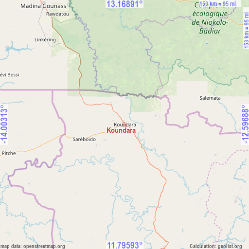
| Upper-left | 13.16891°, | -14.00313° |
| Center: | 12.48333°, | -13.3° |
| Lower-right: | 11.79593°, | -12.59688° |
| Map W x H: | 152.7×152.7 km | = 94.9×94.9mi |
| max Lat: | 12.5311° ⇑2.6% North |
| Koundara: | 12.48333° |
| min Lat: | ⇓97.4% South 7.56748° |
| min Long | Koundara | max Long |
| -14.36667° | -13.3° | -8.53333° |
| W 25.6%⇐ | ⇒74.4% E |
Elevation
Elevation of Koundara is 77 m = 253 ft, and this is 356.4 m = 1169 ft below average elevation for this country.
| Max E: |
1440 m = 4724 ft | 76.9% |
| Avg. | 433.4 m = 1422 ft | |
| Koundara | 77 m = 253 ft | |
Min E: |
0 m = 0 ft | 23.1% |
See also: Guinea elevation on elevation.city.
Geographical zone
Koundara is located in North Torrid zone (between Equator and Tropic of Cancer). Distance of this Northern Tropic circle is 1217.9 km =756.8 mi to North.| Distance of | km | miles | from Koundara |
|---|---|---|---|
| North Pole | 8619 | 5355.6 | to North |
| Arctic Circle | 6013.2 | 3736.4 | to North |
| Tropic Cancer | 1217.9 | 756.8 | to North |
| Equator | 1388 | 862.5 | to South |


Nearby cities:
15 places around Koundara: (largest is in red/bold)
• Boké
203.4 km =126.4 mi,  212°
212°
• Dalaba
229.6 km =142.7 mi,  150°
150°
• Fria
237.3 km =147.5 mi,  187°
187°
• Gaoual
82.3 km =51.1 mi,  172°
172°
• Kimbo
233.2 km =144.9 mi, 186°
• Koubia
182.5 km =113.4 mi,  123°
123°
• Labé
170.3 km =105.8 mi,  139°
139°
• Lélouma
135.6 km =84.3 mi, 150°
• Mali
117.8 km =73.2 mi,  112°
112°
• Pita
186.5 km =115.9 mi, 148°
• Sanguéya
229.8 km =142.8 mi, 210°
• Tondon
235.4 km =146.3 mi,  181°
181°
• Tougué
212.1 km =131.8 mi, 122°
• Télimélé
178.4 km =110.9 mi, 170°
• Youkounkoun
20 km =12.4 mi,  74°
74°
Sources, notices
• [Note1] Compared only with cities in Guinea existing in our database
• [Src1] Map data: © OpenStreetMap contributors (CC-BY-SA)
• [Src2] Other city data from geonames.org with taken over terms of usage.
• [Src3] Geographical zone / Annual Mean Temperature by Robert A. Rohde @ Wikipedia
