Anna Regina geodata
Anna Regina (Pomeroon-Supenaam) is a seat of a first-order administrative division; located in Guyana in America/Guyana (GMT-4) time zone. With population of 12,448 people, there are 3 cities with bigger population in this country. Compared to other cities in Guyana, 92.9% of cities are located further ↓South; 71.4% of cities are located further →East and 85.7% of cities have higher elevation than Anna Regina. Note1


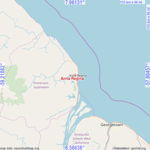
Anna Regina GPS coordinates[2]
7° 15' 51.804" North, 58° 30' 27.684" West
| Map corner | latitude | longitude |
|---|---|---|
| Upper-left | 7.96131°, | -59.21082° |
| Center: | 7.26439°, | -58.50769° |
| Lower-right: | 6.56638°, | -57.80457° |
| Map W x H: | 155.1×155.1 km | = 96.4×96.4mi |
| max Lat: | 8.2° ⇑7.1% North |
| Anna Regina: | 7.26439° |
| min Lat: | ⇓92.9% South 3.38333° |
| min Long | Anna Regina | max Long |
| -59.8° | -58.50769° | -57.13333° |
| W 28.6%⇐ | ⇒71.4% E |
Elevation
Elevation of Anna Regina is 3 m = 10 ft, and this is 12.3 m = 40 ft below average elevation for this country.
| Max E: |
85 m = 279 ft | 85.7% |
| Avg. | 15.3 m = 50 ft | |
| Anna Regina | 3 m = 10 ft | |
Min E: |
0 m = 0 ft | 14.3% |
See also: Guyana elevation on elevation.city.
Geographical zone
Anna Regina is located in North Torrid zone (between Equator and Tropic of Cancer). Distance of Equator is 807.7 km =501.9 mi to South.| Distance of | km | miles | from Anna Regina |
|---|---|---|---|
| North Pole | 9199.3 | 5716.2 | to North |
| Arctic Circle | 6593.4 | 4096.9 | to North |
| Tropic Cancer | 1798.2 | 1117.3 | to North |
| Equator | 807.7 | 501.9 | to South |


Nearby cities:
13 places around Anna Regina: (largest is in red/bold)
• Bartica
96.1 km =59.7 mi,  187°
187°
• Fort Wellington
139.3 km =86.6 mi,  134°
134°
• Georgetown
64.2 km =39.9 mi,  142°
142°
• Linden
141.4 km =87.9 mi,  170°
170°
• Mabaruma
174.9 km =108.7 mi,  306°
306°
• Mahaica Village
91.4 km =56.8 mi, 134°
• Mahaicony Village
109 km =67.7 mi, 134°
• Mahdia
233.2 km =144.9 mi,  197°
197°
• New Amsterdam
157.3 km =97.7 mi, 135°
• Parika
48.3 km =30 mi, 169°
• Rosignol
153.9 km =95.6 mi, 135°
• Skeldon
215.9 km =134.2 mi, 135°
• Vreed-en-Hoop
61.1 km =38 mi,  145°
145°
Sources, notices
• [Note1] Compared only with cities in Guyana existing in our database
• [Src1] Map data: © OpenStreetMap contributors (CC-BY-SA)
• [Src2] Other city data from geonames.org with taken over terms of usage.
• [Src3] Geographical zone / Annual Mean Temperature by Robert A. Rohde @ Wikipedia
