Uttarkāshi geodata
Uttarkāshi (Uttarakhand) is a populated place; located in India in Asia/Kolkata (GMT+5.5) time zone. With population of 17,123 people, there are 2272 cities with bigger population in this country. Compared to other cities in India, 95% of cities are located further ↓South; 53.6% of cities are located further ←West and 96.8% of cities have lower elevation than Uttarkāshi. Note1


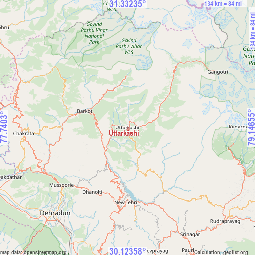
Uttarkāshi GPS coordinates[2]
30° 43' 47.496" North, 78° 26' 36.312" East
| Map corner | latitude | longitude |
|---|---|---|
| Upper-left | 31.33235°, | 77.7403° |
| Center: | 30.72986°, | 78.44342° |
| Lower-right: | 30.12358°, | 79.14655° |
| Map W x H: | 134.4×134.4 km | = 83.5×83.5mi |
| max Lat: | 34.9274° ⇑5% North |
| Uttarkāshi: | 30.72986° |
| min Lat: | ⇓95% South 8.09008° |
| min Long | Uttarkāshi | max Long |
| 68.82655° | 78.44342° | 96.81° |
| W 53.6%⇐ | ⇒46.4% E |
Elevation
Elevation of Uttarkāshi is 1147 m = 3763 ft, and this is 851.4 m = 2793 ft above average elevation for this country.
| Max E: |
3681 m = 12077 ft | 3.2% |
| Uttarkāshi | 1147 m 3763 ft | |
| Avg. | 295.6 m = 970 ft | |
Min E: |
1 m = 3 ft | 96.8% |
See also: India elevation on elevation.city.
Geographical zone
Uttarkāshi is located in North temperate zone (between Tropic of Cancer and the Arctic Circle). Distance of this Northern Tropic circle is 810.9 km =503.9 mi to South.| Distance of | km | miles | from Uttarkāshi |
|---|---|---|---|
| North Pole | 6590.2 | 4095 | to North |
| Arctic Circle | 3984.3 | 2475.7 | to North |
| Tropic Cancer | 810.9 | 503.9 | to South |
| Equator | 3416.8 | 2123.1 | to South |


Nearby cities:
15 places around Uttarkāshi: (largest is in red/bold)
• Barkot
24.3 km =15.1 mi,  291°
291°
• Chakrāta
55.5 km =34.5 mi,  266°
266°
• Clement Town
66.5 km =41.3 mi,  218°
218°
• Dehra Dūn
59.8 km =37.2 mi, 221°
• Devaprayāg
66.7 km =41.4 mi,  166°
166°
• Doiwāla
69 km =42.9 mi,  206°
206°
• Gangotri
56.1 km =34.9 mi,  58°
58°
• Kedārnāth
59.7 km =37.1 mi,  91°
91°
• Mussoorie
47 km =29.2 mi,  229°
229°
• Narendranagar
64.9 km =40.3 mi,  193°
193°
• Rishīkesh
70.7 km =43.9 mi, 191°
• Rāipur
57.6 km =35.8 mi, 216°
• Srīnagar
65.2 km =40.5 mi,  149°
149°
• Tehri
37.9 km =23.5 mi, 174°
• Vikāsnagar
70.4 km =43.7 mi,  245°
245°
Sources, notices
• [Note1] Compared only with cities in India existing in our database
• [Src1] Map data: © OpenStreetMap contributors (CC-BY-SA)
• [Src2] Other city data from geonames.org with taken over terms of usage.
• [Src3] Geographical zone / Annual Mean Temperature by Robert A. Rohde @ Wikipedia
