Barkot geodata
Barkot (Uttarakhand) is a populated place; located in India in Asia/Kolkata (GMT+5.5) time zone. With population of 7,725 people, there are 3147 cities with bigger population in this country. Compared to other cities in India, 95.2% of cities are located further ↓South; 51.1% of cities are located further ←West and 97.1% of cities have lower elevation than Barkot. Note1


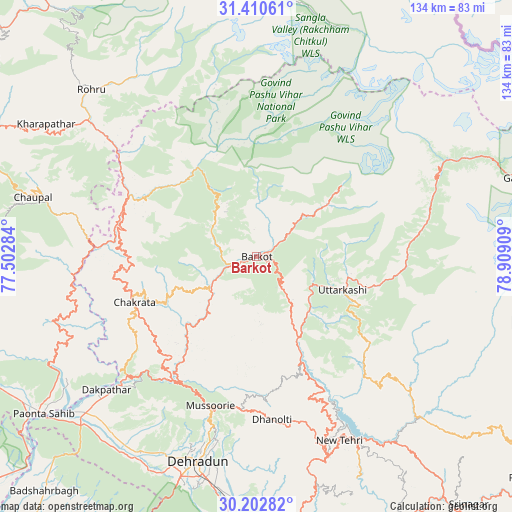
Barkot GPS coordinates[2]
30° 48' 30.996" North, 78° 12' 21.456" East
| Map corner | latitude | longitude |
|---|---|---|
| Upper-left | 31.41061°, | 77.50284° |
| Center: | 30.80861°, | 78.20596° |
| Lower-right: | 30.20282°, | 78.90909° |
| Map W x H: | 134.3×134.3 km | = 83.5×83.5mi |
| max Lat: | 34.9274° ⇑4.8% North |
| Barkot: | 30.80861° |
| min Lat: | ⇓95.2% South 8.09008° |
| min Long | Barkot | max Long |
| 68.82655° | 78.20596° | 96.81° |
| W 51.1%⇐ | ⇒48.9% E |
Elevation
Elevation of Barkot is 1291 m = 4236 ft, and this is 995.4 m = 3266 ft above average elevation for this country.
| Max E: |
3681 m = 12077 ft | 2.9% |
| Barkot | 1291 m 4236 ft | |
| Avg. | 295.6 m = 970 ft | |
Min E: |
1 m = 3 ft | 97.1% |
See also: India elevation on elevation.city.
Geographical zone
Barkot is located in North temperate zone (between Tropic of Cancer and the Arctic Circle). Distance of this Northern Tropic circle is 819.7 km =509.3 mi to South.| Distance of | km | miles | from Barkot |
|---|---|---|---|
| North Pole | 6581.5 | 4089.6 | to North |
| Arctic Circle | 3975.6 | 2470.3 | to North |
| Tropic Cancer | 819.7 | 509.3 | to South |
| Equator | 3425.6 | 2128.6 | to South |


Nearby cities:
15 places around Barkot: (largest is in red/bold)
• Chakrāta
34.7 km =21.6 mi,  250°
250°
• Chaupāl
60.9 km =37.8 mi,  284°
284°
• Clement Town
63.5 km =39.5 mi,  197°
197°
• Dehra Dūn
56.3 km =35 mi, 197°
• Doiwāla
70.8 km =44 mi,  186°
186°
• Harbatpur
60.6 km =37.7 mi,  227°
227°
• Jubbal
62.6 km =38.9 mi,  302°
302°
• Kotkhai
72.2 km =44.9 mi, 298°
• Mussoorie
41.4 km =25.7 mi, 198°
• Pāonta Sāhib
69.3 km =43.1 mi, 233°
• Rohru
61.4 km =38.2 mi,  315°
315°
• Rāipur
56.4 km =35 mi, 191°
• Tehri
53.4 km =33.2 mi,  150°
150°
• Uttarkāshi
24.3 km =15.1 mi,  111°
111°
• Vikāsnagar
56 km =34.8 mi, 227°
Sources, notices
• [Note1] Compared only with cities in India existing in our database
• [Src1] Map data: © OpenStreetMap contributors (CC-BY-SA)
• [Src2] Other city data from geonames.org with taken over terms of usage.
• [Src3] Geographical zone / Annual Mean Temperature by Robert A. Rohde @ Wikipedia
