Barauli geodata
Barauli (Bihar) is a populated place; located in India in Asia/Kolkata (GMT+5.5) time zone. With population of 37,302 people, there are 1180 cities with bigger population in this country. Compared to other cities in India, 73.6% of cities are located further ↓South; 83.3% of cities are located further ←West and 73.9% of cities have higher elevation than Barauli. Note1


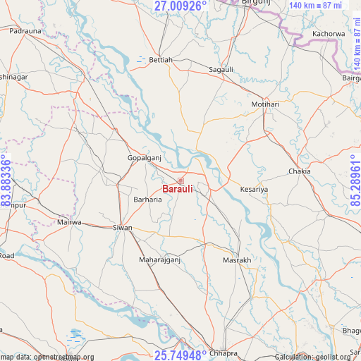
Barauli GPS coordinates[2]
26° 22' 51.924" North, 84° 35' 11.328" East
| Map corner | latitude | longitude |
|---|---|---|
| Upper-left | 27.00926°, | 83.88336° |
| Center: | 26.38109°, | 84.58648° |
| Lower-right: | 25.74948°, | 85.28961° |
| Map W x H: | 140.1×140.1 km | = 87.1×87.1mi |
| max Lat: | 34.9274° ⇑26.4% North |
| Barauli: | 26.38109° |
| min Lat: | ⇓73.6% South 8.09008° |
| min Long | Barauli | max Long |
| 68.82655° | 84.58648° | 96.81° |
| W 83.3%⇐ | ⇒16.7% E |
Elevation
Elevation of Barauli is 73 m = 240 ft, and this is 222.6 m = 730 ft below average elevation for this country.
| Max E: |
3681 m = 12077 ft | 73.9% |
| Avg. | 295.6 m = 970 ft | |
| Barauli | 73 m = 240 ft | |
Min E: |
1 m = 3 ft | 26.1% |
See also: India elevation on elevation.city.
Geographical zone
Barauli is located in North temperate zone (between Tropic of Cancer and the Arctic Circle). Distance of this Northern Tropic circle is 327.4 km =203.4 mi to South.| Distance of | km | miles | from Barauli |
|---|---|---|---|
| North Pole | 7073.8 | 4395.5 | to North |
| Arctic Circle | 4467.9 | 2776.2 | to North |
| Tropic Cancer | 327.4 | 203.4 | to South |
| Equator | 2933.3 | 1822.7 | to South |


Nearby cities:
15 places around Barauli: (largest is in red/bold)
• Bettiah
47.6 km =29.6 mi,  349°
349°
• Chākia
46 km =28.6 mi,  85°
85°
• Dhāka
66.3 km =41.2 mi,  60°
60°
• Gopālganj
17.4 km =10.8 mi,  303°
303°
• Lar
64.6 km =40.1 mi,  252°
252°
• Mahārājgani
31.2 km =19.4 mi,  195°
195°
• Mairwa
45.3 km =28.1 mi, 248°
• Maniar
60.4 km =37.5 mi,  223°
223°
• Marhaura
53.3 km =33.1 mi,  148°
148°
• Mothīhāri
44.3 km =27.5 mi,  47°
47°
• Reoti
62.5 km =38.8 mi, 199°
• Revelganj
65.9 km =40.9 mi,  175°
175°
• Sagauli
45.3 km =28.1 mi,  20°
20°
• Sikandarpur
65.1 km =40.5 mi,  234°
234°
• Siwān
29.1 km =18.1 mi, 232°
Sources, notices
• [Note1] Compared only with cities in India existing in our database
• [Src1] Map data: © OpenStreetMap contributors (CC-BY-SA)
• [Src2] Other city data from geonames.org with taken over terms of usage.
• [Src3] Geographical zone / Annual Mean Temperature by Robert A. Rohde @ Wikipedia
