Sheopur geodata
Sheopur (Madhya Pradesh) is a populated place; located in India in Asia/Kolkata (GMT+5.5) time zone. With population of 62,416 people, there are 705 cities with bigger population in this country. Compared to other cities in India, 68.1% of cities are located further ↓South; 66.4% of cities are located further →East and 56.1% of cities have lower elevation than Sheopur. Note1


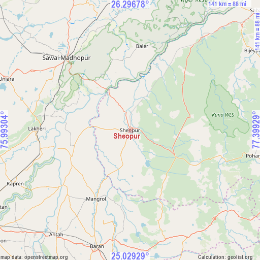
Sheopur GPS coordinates[2]
25° 39' 52.992" North, 76° 41' 46.176" East
| Map corner | latitude | longitude |
|---|---|---|
| Upper-left | 26.29678°, | 75.99304° |
| Center: | 25.66472°, | 76.69616° |
| Lower-right: | 25.02929°, | 77.39929° |
| Map W x H: | 140.9×140.9 km | = 87.6×87.6mi |
| max Lat: | 34.9274° ⇑31.9% North |
| Sheopur: | 25.66472° |
| min Lat: | ⇓68.1% South 8.09008° |
| min Long | Sheopur | max Long |
| 68.82655° | 76.69616° | 96.81° |
| W 33.6%⇐ | ⇒66.4% E |
Elevation
Elevation of Sheopur is 230 m = 755 ft, and this is 65.6 m = 215 ft below average elevation for this country.
| Max E: |
3681 m = 12077 ft | 43.9% |
| Avg. | 295.6 m = 970 ft | |
| Sheopur | 230 m = 755 ft | |
Min E: |
1 m = 3 ft | 56.1% |
See also: Sheopur elevation on elevation.city.
Geographical zone
Sheopur is located in North temperate zone (between Tropic of Cancer and the Arctic Circle). Distance of this Northern Tropic circle is 247.7 km =153.9 mi to South.| Distance of | km | miles | from Sheopur |
|---|---|---|---|
| North Pole | 7153.4 | 4444.9 | to North |
| Arctic Circle | 4547.5 | 2825.7 | to North |
| Tropic Cancer | 247.7 | 153.9 | to South |
| Equator | 2853.6 | 1773.1 | to South |


Nearby cities:
15 places around Sheopur: (largest is in red/bold)
• Anta
69.7 km =43.3 mi,  214°
214°
• Bārān
65.3 km =40.6 mi,  196°
196°
• Gangāpur
89.8 km =55.8 mi,  1°
1°
• Karauli
98.4 km =61.1 mi,  19°
19°
• Keshorai Pātan
86.5 km =53.7 mi,  241°
241°
• Kolāras
104.4 km =64.9 mi,  118°
118°
• Kota
101.4 km =63 mi, 238°
• Kāpren
68.7 km =42.7 mi,  245°
245°
• Lākheri
52 km =32.3 mi,  270°
270°
• Māngrol
41.6 km =25.8 mi, 206°
• Nainwa
85.6 km =53.2 mi,  277°
277°
• Sabalgarh
96.4 km =59.9 mi,  47°
47°
• Sangod
91.8 km =57 mi, 206°
• Sawāi Mādhopur
53.2 km =33.1 mi,  318°
318°
• Shivpuri
100.6 km =62.5 mi,  105°
105°
Sources, notices
• [Note1] Compared only with cities in India existing in our database
• [Src1] Map data: © OpenStreetMap contributors (CC-BY-SA)
• [Src2] Other city data from geonames.org with taken over terms of usage.
• [Src3] Geographical zone / Annual Mean Temperature by Robert A. Rohde @ Wikipedia
