Māngrol geodata
Māngrol (Rajasthan) is a populated place; located in India in Asia/Kolkata (GMT+5.5) time zone. With population of 23,896 people, there are 1778 cities with bigger population in this country. Compared to other cities in India, 65.5% of cities are located further ↓South; 68.3% of cities are located further →East and 58.5% of cities have lower elevation than Māngrol. Note1


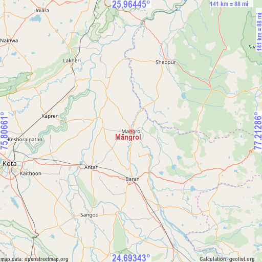
Māngrol GPS coordinates[2]
25° 19' 50.196" North, 76° 30' 35.028" East
| Map corner | latitude | longitude |
|---|---|---|
| Upper-left | 25.96445°, | 75.80661° |
| Center: | 25.33061°, | 76.50973° |
| Lower-right: | 24.69343°, | 77.21286° |
| Map W x H: | 141.3×141.3 km | = 87.8×87.8mi |
| max Lat: | 34.9274° ⇑34.5% North |
| Māngrol: | 25.33061° |
| min Lat: | ⇓65.5% South 8.09008° |
| min Long | Māngrol | max Long |
| 68.82655° | 76.50973° | 96.81° |
| W 31.7%⇐ | ⇒68.3% E |
Elevation
Elevation of Māngrol is 242 m = 794 ft, and this is 53.6 m = 176 ft below average elevation for this country.
| Max E: |
3681 m = 12077 ft | 41.5% |
| Avg. | 295.6 m = 970 ft | |
| Māngrol | 242 m = 794 ft | |
Min E: |
1 m = 3 ft | 58.5% |
See also: India elevation on elevation.city.
Geographical zone
Māngrol is located in North temperate zone (between Tropic of Cancer and the Arctic Circle). Distance of this Northern Tropic circle is 210.6 km =130.9 mi to South.| Distance of | km | miles | from Māngrol |
|---|---|---|---|
| North Pole | 7190.6 | 4468 | to North |
| Arctic Circle | 4584.7 | 2848.8 | to North |
| Tropic Cancer | 210.6 | 130.9 | to South |
| Equator | 2816.5 | 1750.1 | to South |


Nearby cities:
15 places around Māngrol: (largest is in red/bold)
• Anta
29.1 km =18.1 mi,  226°
226°
• Bārān
25.7 km =16 mi,  178°
178°
• Būndi
88.5 km =55 mi,  277°
277°
• Chhabra
81.3 km =50.5 mi,  155°
155°
• Jhālāwār
88.7 km =55.1 mi,  203°
203°
• Keshorai Pātan
57.5 km =35.7 mi,  265°
265°
• Khānpur
67.5 km =41.9 mi,  189°
189°
• Kota
69.4 km =43.1 mi,  256°
256°
• Kāpren
44.5 km =27.7 mi, 280°
• Lākheri
50.6 km =31.4 mi,  318°
318°
• Nainwa
82.4 km =51.2 mi,  306°
306°
• Sangod
50.2 km =31.2 mi,  206°
206°
• Sawāi Mādhopur
78.8 km =49 mi,  347°
347°
• Sheopur
41.6 km =25.8 mi,  26°
26°
• Udpura
85.5 km =53.1 mi,  219°
219°
Sources, notices
• [Note1] Compared only with cities in India existing in our database
• [Src1] Map data: © OpenStreetMap contributors (CC-BY-SA)
• [Src2] Other city data from geonames.org with taken over terms of usage.
• [Src3] Geographical zone / Annual Mean Temperature by Robert A. Rohde @ Wikipedia
