Jalor geodata
Jalor (Rajasthan) is a populated place; located in India in Asia/Kolkata (GMT+5.5) time zone. With population of 49,682 people, there are 893 cities with bigger population in this country. Compared to other cities in India, 65.6% of cities are located further ↓South; 96.6% of cities are located further →East and 55.6% of cities have higher elevation than Jalor. Note1


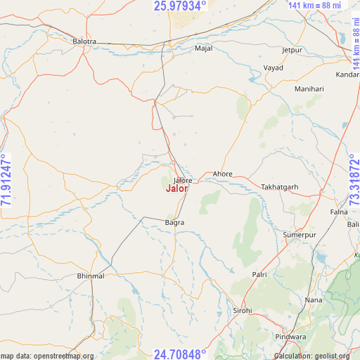
Jalor GPS coordinates[2]
25° 20' 44.088" North, 72° 36' 56.124" East
| Map corner | latitude | longitude |
|---|---|---|
| Upper-left | 25.97934°, | 71.91247° |
| Center: | 25.34558°, | 72.61559° |
| Lower-right: | 24.70848°, | 73.31872° |
| Map W x H: | 141.3×141.3 km | = 87.8×87.8mi |
| max Lat: | 34.9274° ⇑34.4% North |
| Jalor: | 25.34558° |
| min Lat: | ⇓65.6% South 8.09008° |
| min Long | Jalor | max Long |
| 68.82655° | 72.61559° | 96.81° |
| W 3.4%⇐ | ⇒96.6% E |
Elevation
Elevation of Jalor is 172 m = 564 ft, and this is 123.6 m = 406 ft below average elevation for this country.
| Max E: |
3681 m = 12077 ft | 55.6% |
| Avg. | 295.6 m = 970 ft | |
| Jalor | 172 m = 564 ft | |
Min E: |
1 m = 3 ft | 44.4% |
See also: Jalor elevation on elevation.city.
Geographical zone
Jalor is located in North temperate zone (between Tropic of Cancer and the Arctic Circle). Distance of this Northern Tropic circle is 212.2 km =131.9 mi to South.| Distance of | km | miles | from Jalor |
|---|---|---|---|
| North Pole | 7188.9 | 4467 | to North |
| Arctic Circle | 4583 | 2847.7 | to North |
| Tropic Cancer | 212.2 | 131.9 | to South |
| Equator | 2818.2 | 1751.1 | to South |


Nearby cities:
15 places around Jalor: (largest is in red/bold)
• Bhīnmāl
51.8 km =32.2 mi,  221°
221°
• Bāli
69.9 km =43.4 mi,  103°
103°
• Bālotra
65.9 km =40.9 mi,  325°
325°
• Pindwāra
75.3 km =46.8 mi,  144°
144°
• Pāli
85.4 km =53.1 mi,  56°
56°
• Rāni
69.7 km =43.3 mi,  89°
89°
• Samdari
52.1 km =32.4 mi,  355°
355°
• Sheoganj
50.9 km =31.6 mi,  116°
116°
• Sirohi
56 km =34.8 mi,  155°
155°
• Siwāna
39.2 km =24.4 mi, 330°
• Sādri
86.1 km =53.5 mi, 101°
• Sānchor
107.4 km =66.7 mi,  232°
232°
• Takhatgarh
39.2 km =24.4 mi, 93°
• Ābu
84.2 km =52.3 mi,  172°
172°
• Ābu Road
97.7 km =60.7 mi, 170°
Sources, notices
• [Note1] Compared only with cities in India existing in our database
• [Src1] Map data: © OpenStreetMap contributors (CC-BY-SA)
• [Src2] Other city data from geonames.org with taken over terms of usage.
• [Src3] Geographical zone / Annual Mean Temperature by Robert A. Rohde @ Wikipedia
